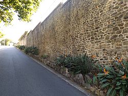
Manly Retaining Wall
| Manly Retaining Wall | |
|---|---|

Structure in 2015
|
|
| Location | Falcon Street, Manly, City of Brisbane, Queensland, Australia |
| Coordinates | 27°27′30″S 153°11′11″E / 27.4583°S 153.1864°ECoordinates: 27°27′30″S 153°11′11″E / 27.4583°S 153.1864°E |
| Design period | 1919 - 1930s (interwar period) |
| Built | 1933 |
| Architect | Eneas Fraser Gilchrist |
| Official name: Manly Retaining Wall, The Great Wall of Manly | |
| Type | state heritage (built) |
| Designated | 5 October 1998 |
| Reference no. | 602039 |
| Significant period | 1930s (fabric) |
| Significant components | steps/stairway, sculpture |
| Builders | Relief work |
Manly Retaining Wall is a heritage-listed embankment at Falcon Street, Manly, City of Brisbane, Queensland, Australia. It was designed by engineer Eneas Fraser Gilchrist and built in 1933 by relief workers. It is also known as The Great Wall of Manly. It was added to the Queensland Heritage Register on 5 October 1998.
The Manly Retaining Wall is located at the corner of Falcon (formerly known as Spring) and Wellington Streets, forming a cutting in the centre of each road. It was constructed in 1933 and comprises irregularly shaped stones which were quarried at Lytton, bedded in concrete.
The first European settlement of the Wynnum-Manly area of Moreton Bay occurred in the 1860s when two sugar mills, Lota and Wyvernleigh were established. The area soon became popular with holiday makers, and holiday homes were constructed along the bay. In 1882 land sales of the Manly Beach Estate (named after the coastal Sydney suburb of Manly) were held, giving the area its present name. The completion of the railway in 1889 provided further impetus for the development of the area as a seaside resort, although the area maintained its connections with the fishing industry. By the late 1920s, access to the area was possible by rail, bus or road, further increasing its popularity as a resort and also as a permanent place of residence for Brisbane businessmen and their families.
Street layouts in the area of the retaining wall form a meandering pattern due to the original estate surveys and also the irregular topography. In some places, the slope to the bay was so steep that the road was divided in two to allow access to houses located on either side of the road.
Falcon Street is an example of this. It was originally divided by an embankment which was so high and wide that it restricted access for two way traffic. A retaining wall to replace the embankment was much needed; however the cost of construction would have been more than the surrounding properties were worth. The initiative of the Brisbane City Council District Engineer for Wynnum in applying for relief labour made the wall a financial possibility.
...
Wikipedia


