Manchester, Georgia
| Manchester, Georgia | |
|---|---|
| City | |

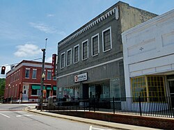
Manchester, Georgia in 2012.
|
|
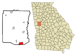
 Location in Meriwether County and the state of Georgia |
|
| Coordinates: 32°51′22″N 84°37′3″W / 32.85611°N 84.61750°WCoordinates: 32°51′22″N 84°37′3″W / 32.85611°N 84.61750°W | |
| Country | United States |
| State | Georgia |
| Counties | Meriwether, Talbot |
| Area | |
| • Total | 5.7 sq mi (14.8 km2) |
| • Land | 5.7 sq mi (14.8 km2) |
| • Water | 0 sq mi (0 km2) |
| Elevation | 883 ft (269 m) |
| Population (2010) | |
| • Total | 3,769 |
| • Density | 699.6/sq mi (269.5/km2) |
| Time zone | Eastern (EST) (UTC-5) |
| • Summer (DST) | EDT (UTC-4) |
| ZIP code | 31816 |
| Area code(s) | 706 |
| FIPS code | 13-49532 |
| GNIS feature ID | 0317652 |
| Website | http://manchester-ga.gov/ |
Manchester is a city located in Meriwether and Talbot Counties in the U.S. state of Georgia, although primarily in Meriwether. The population was 3,769 at the 2010 census.
Manchester is located in west central Georgia along Georgia State Route 85, which leads southwest 39 miles (63 km) to Columbus and northeast 10 miles (16 km) to Woodbury. Georgia 85 meets Georgia State Route 190 south of the city, which leads west 18 miles (29 km) to Pine Mountain. Georgia 85 also meets Georgia State Route 41 in the city, which leads southeast 7 miles (11 km) to Woodland and northwest 4 miles (6 km) to Warm Springs.
As of the census of 2000, there were 3,769 people, 1,629 households, and 1,057 families residing in the city. The population density was 698.1 people per square mile (269.7/km²). There were 1,853 housing units at an average density of 324.4 per square mile (125.3/km²). The racial makeup of the city was 56.22% White, 42.23% African American, 0.33% Native American, 0.65% Asian, 0.10% from other races, and 0.48% from two or more races. Hispanic or Latino of any race were 0.70% of the population.
...
Wikipedia
