Mamers Valles
 |
|
| Coordinates | 40°18′N 342°12′W / 40.3°N 342.2°WCoordinates: 40°18′N 342°12′W / 40.3°N 342.2°W |
|---|---|
| Length | 1,020.0 |
| Naming | Word for "Mars" in Oscan. |
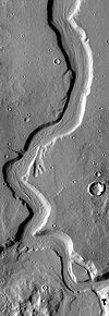
Mamers Valles is a long, winding canyon in the north of Mars. It covers 1000 km, cutting through the cratered uplands of the Arabia Terra, from the Cerulli Crater to the Deuteronilus Mensae near the edge of Mars' vast northern lowlands. Through its midsection, it averages a width of 25 km and a depth of 1200 meters.
The most popular theory states that the canyon was likely formed by either water or lava, with the flow from south to north and additional material flowing from the slope toward the valley floor. According to the most popular theory, linear features on the valley bottom indicate possible ice flows and that ice may currently be plentiful. Mamers Valles is dated to the early Hesperian period, about 3.8 billion years ago.
An infeeder canyon at the northwestern edge of Mamers Valles, near their mouth (seen at the bottom of the photo at lower right), is a box canyon. Such canyons (with rounded headwalls and no obvious overland infeeders) have been widely presumed to have formed by a process of seepage erosion. However, it has been suggested that this side canyon was formed by a catastrophic flood event (Lamb, 2008). The case is supported by comparison with Box Canyon, Idaho, USA, which shows a similar morphology, but also exhibits features such as plunge pools, rock scours on the headwall rim, and a notch on the headwall rim, suggestive of large-volume flow.
Mamers Valles was named in 1976, after the Oscan word for Mars.
Wide view of Mamers Valles with cliffs, as seen by HiRISE.
Smooth cliff of Mamers Valles. Note the lack of boulders. Much of the surface may have just been blown in or dropped from the sky (as dirty frost). Image from HiRISE.
Layered deposit in Mamers Valles, as seen by HiRISE.
...
Wikipedia
