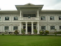
Malitbog, Bukidnon
| Malitbog | ||
|---|---|---|
| Municipality | ||

Municipal/Town Hall
|
||
|
||
 Map of Philippines with Malitbog highlighted |
||
| Location within the Philippines | ||
| Coordinates: 8°32′N 124°53′E / 8.53°N 124.88°ECoordinates: 8°32′N 124°53′E / 8.53°N 124.88°E | ||
| Country | Philippines | |
| Region | Northern Mindanao (Region X) | |
| Province | Bukidnon | |
| District | 1st district of Bukidnon | |
| Founded | June 25, 1963 | |
| Barangays | 11 | |
| Government | ||
| • Mayor | Osmundo N. dela Rosa | |
| Area | ||
| • Total | 581.85 km2 (224.65 sq mi) | |
| Population (2015 census) | ||
| • Total | 24,453 | |
| • Density | 42/km2 (110/sq mi) | |
| Time zone | PST (UTC+8) | |
| ZIP code | 8704 | |
| IDD : area code | +63 (0)88 | |
| Income class | 2nd municipal income class | |
| 101313000 | ||
| Electorate | 15,387 voters as of 2016 | |
| Website | www |
|
Malitbog is a second class municipality in the province of Bukidnon, Philippines. According to the 2015 census, it has a population of 24,453 people.
The pioneers of the municipality were a group of Bukidnon tribe who has a small settlement along a spring called Abo-on.
As their number increased, they began to call the entire area as Abo-on. However, there were divergent opinions to have this name because Abo-on refer only to a small cluster of settlers in the area.
The name was then changed to Malitbog, on the account of Malitbog River transversing their settlement and likewise the principal source of fishing, the native’s favorite livelihood. Their seat of government near the Malitbog River was also another consideration.
By virtue of Executive No. 42, dated June 25, 1963, Malitbog became a 5th Class municipality by operation of the provision of Section 2 of Republic Act 1515 and considered a regular municipality pursuant to Republic Act 23 and 88 duly signed by President Diosdado Macapagal.
Malitbog is located at the northernmost part of the province, between parallel 8°25'35" and 8°36'8" North Latitude and Meridians 124°49'39" and 125°11'39" East Longitude. Malitbog is a land locked municipality bounded on north by the municipality of Claveria and on the western side by Tagoloan - both of which are part of Misamis Oriental. Bounding it on its southern part are the municipalities of Manolo Fortich and Impasugong of Bukidnon Province while on its eastern side is the municipality of Esperanza, Agusan del Sur.
The Municipality is about 40 kilometres (25 mi) from the regional capital - Cagayan de Oro City, and about 2½ hours ride from the Provincial Capital, Malaybalay City. It is reachable via Tagoloan and is approximately 2 hours ride from the City of Cagayan de Oro through secondary and first class road type (gravel and concrete pavement).
...
Wikipedia


