Malham Tarn
| Malham Tarn | |
|---|---|

A view of the north-east corner of Malham Tarn
|
|

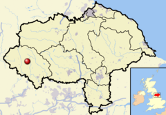
Malham Tarn shown within North Yorkshire
|
|
| Location | Yorkshire Dales, England |
| Coordinates | 54°05′45″N 2°10′0″W / 54.09583°N 2.16667°WCoordinates: 54°05′45″N 2°10′0″W / 54.09583°N 2.16667°W |
| Type | Glacial |
| Catchment area | 6 km2 (2.3 sq mi) |
| Basin countries | United Kingdom |
| Surface area | 0.62 km2 (0.24 sq mi) |
| Average depth | 2.4 m (7.9 ft) |
| Max. depth | 4.4 m (14 ft) |
| Residence time | 11 weeks |
| Surface elevation | 377 m (1,237 ft) |
| Designated | 28 October 1993 |
Malham Tarn is a glacial lake near the village of Malham in the Yorkshire Dales, England. The lake is one of only eight upland alkaline lakes in Europe. At an altitude of 377 metres (1,237 ft) above sea level it is the highest marl lake in the United Kingdom. Its geology, flora and fauna have led to it being listed under a number of conservation designations. The site is currently owned by the National Trust, who lease part of the site to the Field Studies Council who offer residential and non-residential field courses there. The site was the inspiration for Charles Kingsley's 1863 novel, The Water-Babies, A Fairy Tale for a Land Baby.
Malham Tarn is situated in the Yorkshire Dales, a national park in the Yorkshire Pennines. It lies approximately 25 miles (40 km) north-west of Bradford and about 2.5 miles (4.0 km) north of the nearest settlement, Malham.
At 377 metres (1,237 ft) above sea level it is sometimes, but erroneously, considered the highest lake in England, but there are lakes at higher altitudes such as Innominate Tarn. It is, however, the highest marl lake in Great Britain. The lake is one of only eight upland alkaline lakes in Europe having a pH between 8.0 and 8.6. The catchment area of the lake is 600 hectares (6.0 km2; 2.3 sq mi) and the main inflow is a stream at the lake's north-west corner. The lake is 4.4 metres (14 ft) at its deepest, with an average depth of 2.4 metres (7.9 ft) and the surface area is 62 hectares (0.62 km2; 0.24 sq mi). It takes approximately 11 weeks for water to leave the lake after it has entered. The primary outflow is a small stream at the southern end of the lake. The outflow stream goes underground after approximately 500 metres (1,600 ft) before emerging downstream of Malham Cove as a source of the River Aire.
...
Wikipedia
