Male’
|
Malé މާލެ |
|
|---|---|
| City | |

Aerial view of the whole of Malé on the eponymous island as seen from the southwest
|
|
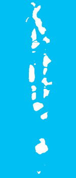
| Location of Malé in the Maldives | |
| Coordinates: 04°10′31″N 073°30′32″E / 4.17528°N 73.50889°E | |
| Country | Maldives |
| Geographic atoll | North Malé Atoll |
| Government | |
| • Council | Malé City Council (MDP) |
| • Mayor | Mohammed Shihab |
| Area | |
| • Total | 5.8 km2 (2.2 sq mi) |
| Elevation | 2.4 m (7.9 ft) |
| Population (2014) | |
| • Total | 133,412 |
| • Density | 23,002/km2 (59,570/sq mi) |
| Time zone | MVT (UTC+05:00) |
| Assigned Letter | T |
| Area code(s) | 331, 332, 333, 334 |
| ISO 3166 code | MV-MLE |
Coordinates: 04°10′31″N 073°30′32″E / 4.17528°N 73.50889°E
Malé (/ˈmɑːl.eɪ/, local pronunciation: [ˈmɑːlɛ] Maldivian: މާލެ) is the capital and most populous city in the Republic of Maldives. With a population of 133,412 and an area of 5.8 square kilometres (2.2 sq mi), it is also one of the most densely populated cities in the world. The city is geographically located at the southern edge of North Malé Atoll (Kaafu Atoll). Administratively, the city consists of a central island, an airport island, and two other islands governed by the Malé City Council.
Traditionally it was the King's Island, from where the ancient royal dynasties ruled and where the palace was located. The city was then called Mahal. Formerly it was a walled city surrounded by fortifications and gates (doroshi). The Royal Palace (Gan'duvaru) was destroyed along with the picturesque forts (kotte) and bastions (buruzu) when the city was remodelled under President Ibrahim Nasir's rule in the aftermath of the abolition of the monarchy in 1968. However, the Malé Friday Mosque remains. In recent years, the island has been considerably expanded through land-filling operations. Over the years, Malé has been the center of political protests and milestone events.
...
Wikipedia

