Malakoff Diggins State Historic Park
| Malakoff Diggins State Historic Park | |
|---|---|

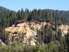
Canyon wall created by hydraulic mining at Malakoff Diggins State Historic Park
|
|
| Location | Nevada County, California, USA |
| Nearest city | Nevada City, California |
| Coordinates | 39°21′46″N 120°55′28″W / 39.36278°N 120.92444°WCoordinates: 39°21′46″N 120°55′28″W / 39.36278°N 120.92444°W |
| Area | 3,143 acres (12.72 km2) |
| Established | 1965 |
| Governing body | California Department of Parks and Recreation |
|
Malakoff Diggins-North Bloomfield Historic District
|
|
| Area | 865 acres (350 ha) |
| Built | c. 1850–1899 |
| NRHP Reference # | 73000418 |
| Added to NRHP | April 11, 1973 |
Malakoff Diggins State Historic Park is a state park unit preserving the largest hydraulic mining site in California, United States. The mine pit and several Gold Rush-era buildings were listed on the National Register of Historic Places as the Malakoff Diggins-North Bloomfield Historic District. The "canyon" is 7,000 feet (2,100 m) long, as much as 3,000 feet (910 m) wide, and nearly 600 feet (180 m) deep in places. Visitors can see huge cliffs carved by mighty streams of water, results of the mining technique of washing away entire mountains of gravel to wash out the gold. The park is a 26-mile (42 km) drive north-east of Nevada City, California, in the Gold Rush country. The 3,143-acre (1,272 ha) park was established in 1965.
The Malakoff mine pit on the San Juan Ridge is the impetus for one of the nation's first environmental protection measures.
In 1850 there was little gold left in streams. Miners began to discover gold in old riverbeds and on mountainsides high above the streams. In 1851 three miners headed northeast of what is now Nevada City for a less crowded area to prospect. One miner went back to town with a pocket full of gold nuggets for supplies and was followed back by many prospectors. These followers, however, did not find any gold and declared the area "Humbug", thus the stream was so named "Humbug Creek". Around 1852, settlers began to arrive in the area and the town of "Humbug" sprang up. These miners could not decide how to move the dirt to a place where there was water.
By 1853 miners invented a new method of mining called hydraulic mining. Dams were built high in the mountains. The water traveled from the reservoirs through a wooden canal called a flume that was up to 45 miles (72 km) long. The water ran swiftly to the canvas hoses and nozzles called monitors waiting in the old riverbeds. The miners would aim the monitors at the hillsides to wash the gravel into huge sluices. Over time the monitors became bigger and more powerful. Their force was so great they could toss a fifty-pound rock like a cannonball or even kill a person. Over 300 Chinese worked on this project and two Chinese settlements existed in North Bloomfield.
...
Wikipedia


