Majayjay, Laguna
| Majayjay | |||||
|---|---|---|---|---|---|
| Municipality | |||||
| Bayan ng Majayjay | |||||
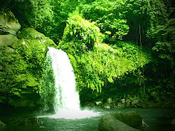
From Clockwise from top: Taytay Falls, Saint Gregory the Great Parish Church, & Chapel of Nuestra Señora de la Porteria, also known as Ermita.
|
|||||
|
|||||
| Nickname(s): Town of Rivers and Waterfalls | |||||
 Map of Laguna showing the location of Majayjay |
|||||
| Location within the Philippines | |||||
| Coordinates: 14°09′N 121°28′E / 14.15°N 121.47°ECoordinates: 14°09′N 121°28′E / 14.15°N 121.47°E | |||||
| Country | Philippines | ||||
| Region | CALABARZON (Region IV-A) | ||||
| Province | Laguna | ||||
| District | 4th district of Laguna | ||||
| Founded | October 2, 1571 | ||||
| Barangays | 40 | ||||
| Government | |||||
| • Mayor | Carlo Invinzor B. Clado | ||||
| • Vice Mayor | Eulogio Wilson Amorado | ||||
| • Representative | Benjamin C. Agarao, Jr. | ||||
| • Sangguniang Bayan | |||||
| Area | |||||
| • Total | 69.58 km2 (26.86 sq mi) | ||||
| Highest elevation | 836 m (2,743 ft) | ||||
| Population (2015 census) | |||||
| • Total | 27,792 | ||||
| • Density | 400/km2 (1,000/sq mi) | ||||
| Time zone | PST (UTC+8) | ||||
| ZIP code | 4005 | ||||
| IDD : area code | +63 (0)49 | ||||
| Income class | 4th | ||||
Majayjay (Filipino: Bayan ng Majayjay) is a 4th class municipality in the province of Laguna, Philippines. It is located at the foot of Mount Banahaw, and stands 1,000 feet above sea level. One hundred twenty kilometers south of Manila, it is bounded by the municipality of Magdalena on the north-west, by Lucban in Quezon province on the southeast, by Luisiana on the north-east, and by Liliw on the west. According to the 2015 census, it has a population of 27,792 people.
Majayjay has the Taytay Falls, also called the Majayjay Falls or Imelda Falls, because ex-First Lady Imelda Marcos financed the promotion of tourism in this place. It is a two-storey high falls located in a remote scenery where the forestry is abundant. To reach Taytay Falls, one has to go down the stone steps leading to a kilometer-long trail. Constructed in 2008, during the past, reaching Taytay Falls is a very hard task, as there were no marked trails during that time. Recently, the World Bank has sponsored the promotion of tourism in Taytay Falls.
Indigenous residents use to call it Malay Barangay. The Spanish colonial government made it a town in 1578.
During this period, Malay Barangay was one of the most populated settlements in the newly founded province. It competed with Bay and Pagsanjan during the selection of the province’s capital.
The popularity of this new town grew instantly during the Spanish period. Its location at the foot of the mountain gave it an abundant supply of fresh mountain spring water. Four rivers flowed through the town. They were Initian, Oobi and Ula, from the towering mountain, and Balanac from the falls of Botocan where all the three rivers meet.
Botocan Falls and the town’s scenery were uniquely famous. Europeans and wealthy natives from Manila frequently visited the town. However, the road to Malay Barangay was tough. Guests have to be ferried from Manila through the Pasig River to Laguna de Bay. Land travel began by mounting on horses through a path in the forest, and then borne by natives in hammocks on the way up to Malay Barangay.
...
Wikipedia


