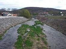
Mahoning Creek (Susquehanna River)
| Mahoning Creek | |
|---|---|

Mahoning Creek
|
|
|
Satellite map of Mahoning Creek. The red dot is the stream's source and blue dot is its mouth.
|
|
| Basin features | |
| Main source | valley in Madison Township, Columbia County, Pennsylvania between 1,080 and 1,100 feet (330 and 340 m) |
| River mouth | Susquehanna River in Danville, Montour County, Pennsylvania 463 ft (141 m) 40°57′54″N 76°37′54″W / 40.9649°N 76.6316°WCoordinates: 40°57′54″N 76°37′54″W / 40.9649°N 76.6316°W |
| Progression | Susquehanna River → Chesapeake Bay |
| Basin size | 39.6 sq mi (103 km2) |
| Tributaries |
|
| Physical characteristics | |
| Length | 10.6 mi (17.1 km) |
Mahoning Creek is a tributary of the Susquehanna River in Columbia County and Montour County, in Pennsylvania, in the United States. It is approximately 10.6 miles (17.1 km) long and flows through Madison Township in Columbia County and West Hemlock Township, Derry Township, Valley Township, Mahoning Township, and Danville in Montour County. The watershed of the creek has an area of 39.6 square miles (103 km2). Its tributaries include Kase Run, Mauses Creek, and Sechler Run. Mahoning Creek is designated as a Trout-Stocking Fishery and a Migratory Fishery for part of its length and as a Warmwater Fishery and a Migratory Fishery for the remainder.
Mahoning Creek is considered by the Pennsylvania Department of Environmental Protection to be impaired by siltation. The main rock formations in the watershed include the Trimmers Rock Formation, the Clinton Group, the Catskill Formation, the Hamilton Group, the Bloomsburg and Mifflintown Formation, the Onondaga and Old Port Formation, and the Wills Creek Formation. The main soils include the Berks-Weikert-Alvira series, the Chenango-Pope-Holly series, the Clymer-Buchanan-Norwich series, and the Leck Kill-Meckesville-Calvin series. Most of the watershed is forested or agricultural land, but there is some developed land.
There was historically a village of the Delaware tribe near the mouth of Mahoning Creek. The first people of European descent arrived in the area in the 1760s and 1770s. Various mills were constructed on it in the 1700s and 1800s. Numerous bridges have also been constructed across the creek. Part of the creek is in the Montour Ridge Landscape Corridor.
...
Wikipedia
