Magalang
| Magalang | ||
|---|---|---|
| Municipality | ||

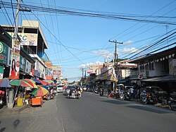
Downtown Magalang
|
||
|
||
| Nickname(s): Sweet Tamarind Capital of The Philippines | ||
| Motto: ONE MAGALANG!,Metung King Panyulung! | ||
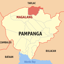
 Map of Pampanga showing the location of Magalang |
||
| Location within the Philippines | ||
| Coordinates: 15°13′N 120°40′E / 15.217°N 120.667°ECoordinates: 15°13′N 120°40′E / 15.217°N 120.667°E | ||
| Country | Philippines | |
| Region | Central Luzon (Region III) | |
| Province | Pampanga | |
| District | 1st District | |
| Founded | April 30, 1605 | |
| Present Site | December 13, 1863 | |
| Barangays | 27 | |
| Government | ||
| • Mayor | Maria Lourdes P. Lacson (NPC) | |
| • Vice Mayor | Norman L. Lacson (NPC) | |
| • Councilors |
Councilors
|
|
| • Representative of 1st District | Carmelo "Jon" Lazatin II Lingap Lugud |
|
| Area | ||
| • Total | 97.32 km2 (37.58 sq mi) | |
| Elevation | 300 m (1,000 ft) | |
| Population (2015) | ||
| • Total | 113,147 | |
| • Density | 1,200/km2 (3,000/sq mi) | |
| Time zone | PST (UTC+8) | |
| ZIP code | 2011 | |
| IDD : area code | +63 (0)45 | |
| Income class | 1st class | |
| Website | magalang |
|
Magalang is a municipality located within the province of Pampanga in the Philippines. Magalang is part of the First Congressional District of Pampanga where Angeles City and Mabalacat City are also included. According to the 2015 census, it has a population of 113,147.
Magalang was mentioned as visita of nearby town of Arayat in December 29, 1598. In April 30, 1605, it was separated by the Augustinians from Arayat and attained township status due to bajo de la campana system. Augustinians appointed Fr. Gonzalo de Salazar, OSA as the first pastor. Magalang was initially called Magalo derived from Kapampangan word "Galo" which is means, wavy and moving; describing the dangerous water flows of Parua River. The town proper was located in Macapsa, however due to the natural calamities and revolts led by Andres Malong and his subordinate Melchor de Vera against the Spanish in 1660, it was nearly abandoned. It was moved to San Bartolome in 1734 until it was swept by the flood due to the overflow of Parua River in 1863. Transferred to the present site in barrio San Pedro Talimunduc on December 13, 1863 led by the parish priest, Fr. Ignacio Manzanares, OSA and some of the members of principalia including Pablo M. Luciano, gobernadorcillo of Magalang at that time. In 1885, the agricultural experiment station, La Granja Modelo de Luzon was transferred from San Isidro, Nueva Ecija to the foothills in Mt. Arayat; in which become the present Pampanga State Agricultural University. The revolutionary government took over the local government on June 12, 1898 led by General Francisco Macabulos and Colonel Lorenzo D. Camaya; and during that time, Magalang was one of the revolutionary centers in Pampanga due to its proximity to Camansi, a revolutionaries' headquarters located in Mt. Arayat. The forces of Major General Servillano Aquino defended Magalang against Americans until it was successfully captured on November 5, 1899 led by Major General Arthur MacArthur and Colonel Jacob H. Smith. On January 1, 1942, Japanese forces defeated the Filipino-American forces composed of Igorot troops led by Major Helmert Duisterhof and Capt. Russell W. Volckmann; paving away for the capture of Magalang. It was liberated by the 148th Infantry of 37th Division, US Army with the help of Hukbalahap on January 25, 1945. It was one of the hotbeds of Huk insurgency until the rebellion crushed in 1954. On December 30, 1963, Mayor Benedicto T. Dayrit was assassinated by the alleged men of Commander Sumulong during the night ball in town plaza. In 1968, Mayor Daniel T. Lacson was sworn as mayor of Magalang until his term was ended in 1986. During the tenure of Mayor Pastor Z. Guiao, Magalang was awarded as one of the cleanliest municipality in the Philippines. Mayor Maria Lourdes P. Lacson was sworn as mayor of Magalang in June 30, 2016; the first woman mayor of Magalang.
...
Wikipedia


