MBTA Commuter Rail
 |
|

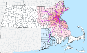
MBTA Commuter Rail system map
|
|

MBTA train at Route 128 Station on the Providence/Stoughton Line.
|
|
| Reporting mark | MBTX |
|---|---|
| Locale | Eastern Massachusetts and Rhode Island |
| Dates of operation | 1964 (beginning of MBTA subsidies) 1973 and 1976 (MBTA asset purchases) 1981 (full consolidation)– |
| Track gauge | 4 ft 8 1⁄2 in (1,435 mm) (Standard gauge) |
| Length | 398 miles (641 km) |
| Headquarters | Boston, MA, USA |
| Website | MBTA.com |
The MBTA Commuter Rail system serves as the commuter rail arm of the Massachusetts Bay Transportation Authority's transportation coverage of Greater Boston in the United States. It is operated under contract by Keolis, which took over operations on July 1, 2014 from the Massachusetts Bay Commuter Railroad Company (MBCR).
The system is the sixth-busiest commuter rail in the U.S., behind the New York, Chicago, and Philadelphia area systems, and is tied for fifth-busiest with Philadelphia's SEPTA Regional Rail in terms of weekday ridership. The line's characteristic purple-trimmed coaches operate as far south as North Kingstown, Rhode Island, and as far north as Newburyport and as far west as Fitchburg, both in Massachusetts.
Trains originate at two major terminals in Boston — South Station and North Station — both transportation hubs offering connections to Amtrak, local bus, and subway lines, but as yet have no passenger rail infrastructure directly connecting them, outside of using the existing MBTA subway lines. MassDOT is currently entering into a study phase of the North–South Rail Link, which would provide a solution to the problem. In the third quarter of 2015, daily weekday ridership was 121,600.
The following lines terminate at South Station (listed from southeast to west):
The following lines terminate at North Station (listed from west to northeast):
...
Wikipedia
