M-40 (Spain)
| Autopista M-40 | |
|---|---|
| Circunvalación de Madrid | |
 |
|
| Route information | |
| Part of |
|
| Length: | 63.3 km (39.3 mi) |
| Highway system | |
| Autopistas and autovías in Spain | |
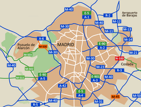
The M-40, in Spanish transport, is a Madrid orbital motorway, similar to the M25 motorway in London, or the Boulevard Périphérique in Paris. It is the second-outermost of the Madrid orbital highways, the M-30 being the closest to the centre of Madrid.
It has a total length of 63.3 km (39.3 mi), looping around Madrid and its suburb Pozuelo de Alarcón at a mean distance of 10.1 km (6.3 mi) to the Puerta del Sol. The actual distance is much closer in the southern and eastern spans, which have been engulfed by the city in some points; than in the west, where the Casa de Campo and the projection towards Pozuelo brings it further from Madrid itself.
Furthermore, it is the only one of the several ring roads serving Madrid that runs as a full-fledged motorway for all its length: a span about 2 kilometres (1.2 mi) long at the northern arc of the inner M-30 are not freeway-grade, having level crossings and traffic lights; while the outermost M-50 is not a full ring road due to the interruption caused by the Mount of El Pardo protected natural zone. With the "normal" M-40 traffic already being one of the heaviest in Spain, this provides for mighty jams in its northern span during peak hours. The Madrid regional government, which built the M-45 motorway external to the M-40 specifically to decongest the southern and eastern spans of the older beltway, has recently aired plans to address the northern jams by effectively "closing" the M-50 ring with a tunnel under the protected area.
...
Wikipedia

