Mühlehorn
| Mühlehorn | ||
|---|---|---|
| Former municipality of Switzerland | ||
 |
||
|
||
| Coordinates: 47°7′N 9°10′E / 47.117°N 9.167°ECoordinates: 47°7′N 9°10′E / 47.117°N 9.167°E | ||
| Country | Switzerland | |
| Canton | Glarus | |
| District | n.a. | |
| Area | ||
| • Total | 7.75 km2 (2.99 sq mi) | |
| Elevation | 428 m (1,404 ft) | |
| Population (December 2015) | ||
| • Total | 416 | |
| • Density | 54/km2 (140/sq mi) | |
| Postal code | 8874 | |
| SFOS number | 1618 | |
| Surrounded by | Amden (SG), Obstalden, Quarten (SG) | |
| Website |
www SFSO statistics |
|
Mühlehorn is a former municipality in the canton of Glarus in Switzerland. Effective from 1 January 2011, Mühlehorn is part of the municipality of Glarus Nord.
Mühlehorn is first mentioned in 1551 as Mülihorn.
Mühlehorn has an area, as of 2006[update], of 7.8 km2 (3.0 sq mi). Of this area, 33.8% is used for agricultural purposes, while 52.4% is forested. Of the rest of the land, 3.9% is settled (buildings or roads) and the remainder (9.9%) is non-productive (rivers, glaciers or mountains).
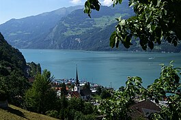
Mühlehorn is located on the southern shore of the Walensee. It consists of the village of Mühlehorn and the hamlets of Vortobel, Tiefenwinkel and Mühletal which are on the north-east border of the canton.
Mühlehorn had a population (as of 2010) of 416. As of 2007[update], 13.4% of the population was made up of foreign nationals. Over the last 10 years the population has decreased at a rate of -13.2%. Most of the population (as of 2000[update]) speaks German (88.9%), with Serbo-Croatian being second most common ( 7.9%) and Italian being third ( 1.1%).
In the 2007 federal election the most popular party was the SPS which received 54% of the vote. Most of the rest of the votes went to the SVP with 31% of the vote.
In Mühlehorn about 67.3% of the population (between age 25-64) have completed either non-mandatory upper secondary education or additional higher education (either University or a Fachhochschule).
...
Wikipedia


