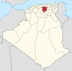
M'Sila Province
|
M'Sila Province ولاية المسيلة |
|
|---|---|
| Province | |
 Map of Algeria highlighting M'Sila |
|
| Coordinates: 35°42′N 4°33′E / 35.700°N 4.550°ECoordinates: 35°42′N 4°33′E / 35.700°N 4.550°E | |
| Country |
|
| Capital | M'Sila |
| Area | |
| • Total | 18,718 km2 (7,227 sq mi) |
| Population (2008) | |
| • Total | 991,846 |
| • Density | 53/km2 (140/sq mi) |
| Time zone | CET (UTC+01) |
| Area Code | +213 (0) 35 |
| ISO 3166 code | DZ-28 |
| Districts | 15 |
| Municipalities | 47 |
M'Sila (also spelled Msila, M'sila or MSila) (Arabic: ولاية المسيلة) is a province (wilaya) of northern Algeria. It has a population of 1 million people and an area of 18,718 km², while its capital, also called M'sila, home to M'Sila University, has a population of about 100,000. Some localities in this wilaya are Bou Saada and Maadid. Chott El Hodna, a salt lake, crosses into M'Sila. However, most of the region is semi-arid and undeveloped.
M'Sila is primarily known for its farming.
Additionally, M'Sila was the location of the first village constructed as part of a government-run program to transition nomadic Algerians to sedentary life using local materials. The village, now complete, was dubbed Maader and consists of houses, public and trading areas, and a mosque.
The province is divided into 15 districts (daïras), which are further divided into 47 communes or municipalities.
...
Wikipedia
