Luton to Dunstable Busway
| Busway | |||
|---|---|---|---|
| Luton to Dunstable Busway | |||
 |
|||

Bus at Stanton Road bus stop, Luton
|
|||
| Route | |||
| Start | Luton Airport | ||
| Via | Luton | ||
| End | Houghton Regis | ||
| Timetable | Timetables | ||
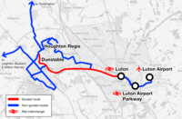
| Map | Route map | ||
|
|||
The Luton-Dunstable Busway is a guided busway system in Bedfordshire, England, which connects the towns of Dunstable, Houghton Regis and Luton with Luton Airport. It was built on the route of a disused railway track and opened in September 2013. The busway runs parallel to the A505 (Dunstable Road) and A5065 (Hatters Way) for 13.4 kilometres (8.3 mi), of which 7.7 kilometres (4.8 mi) is guided track with a maximum speed of 50 mph. It is claimed to be the second longest busway in the world.
Various studies had been carried out since 1989 which examined options for solving transit problems in the Luton/Dunstable Urban Area, including British Rail's Network SouthEast Plan published in May 1989. Bedfordshire County Council considered a number of possible schemes, including a single-track extension of Thameslink heavy rail services from Luton to Dunstable; a single-track diesel-powered rail shuttle service; a twin-track light rail system, with a possible extension to Luton Airport; and a segregated guided busway system. The guided bus scheme was selected in 1996 as the most cost-effective option. In April 1997, the newly created unitary authority of Luton Borough Council took over the lead role in the project. A process of ongoing consultations, grant applications and a public enquiry delayed the project by several years.
...
Wikipedia

