Lucena, Philippines
| Lucena City | ||||||
|---|---|---|---|---|---|---|
| Highly Urbanized City | ||||||
| City of Lucena | ||||||
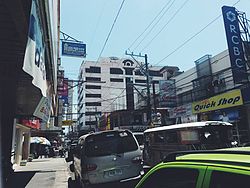
From Top to Bottom: Lucena City Government Complex, St. Ferdinand Cathedral, Quezon Provincial Capitol, Busiest Streets of Lucena City.
|
||||||
|
||||||
Nickname(s):
|
||||||
| Motto: Sama-Sama sa Bagong Lucena! | ||||||
 Map of Quezon showing the location of Lucena City |
||||||
| Location within the Philippines | ||||||
| Coordinates: 13°56′N 121°37′E / 13.93°N 121.62°ECoordinates: 13°56′N 121°37′E / 13.93°N 121.62°E | ||||||
| Country | Philippines | |||||
| Region | CALABARZON (Region IV-A) | |||||
| Province | Quezon (geographically only) | |||||
| District | 2nd district of Quezon | |||||
| Incorporated | June 1, 1882 (Town) | |||||
| Incorporated | August 20, 1961 (City) | |||||
| Incorporated | July 1, 1991 (Highly Urbanized City) | |||||
| Barangays | 33 | |||||
| Government | ||||||
| • Representative | Vicente J. Alcala (LP) | |||||
| • Mayor | Roderick A. Alcala (LP) | |||||
| • Vice Mayor | Philip M. Castillo (LP) | |||||
| Area | ||||||
| • Total | 80.21 km2 (30.97 sq mi) | |||||
| Elevation | 15.2 m (49.9 ft) | |||||
| Population (2015 census) | ||||||
| • Total | 266,248 | |||||
| • Density | 3,300/km2 (8,600/sq mi) | |||||
| Demonym(s) | Lucenahin | |||||
| Time zone | PST (UTC+8) | |||||
| ZIP Code | 4300, 4301 | |||||
| IDD : area code | +63 (0)42 | |||||
| Income class | 1st Class, Highly Urbanized | |||||
| Website | lucenacity |
|||||
Lucena, officially the City of Lucena (Filipino: Lungsod ng Lucena), is a first class highly urbanized city and it is the capital city of the province of Quezon, Philippines and the only first class Highly Urbanized City located in the Calabarzon Region. According to the 2015 census, it has a population of 266,248 people making the most populous area in the province.
For statistical and geographical purposes, Lucena City is grouped with Quezon but governed administratively independent from the province.
In the 1570s, Capitan Juan de Salcedo first explored what was the province of Tayabas. The Franciscan priests Juan de Plasencia and Diego de Oropesa between 1580 and 1583 founded its town, also named Tayabas. Tayabas was organized by the Spaniards through the Franciscan missionaries and Lucena was just one of its barrios.
The Spaniards of the 16th century called the area "Buenavista" because of its scenic beauty; several years later, the barrio was renamed "Oroquieta". A century later, Muslim pirates began terrorizing the entire Philippine coastline, and Oroquieta was not spared from the notorious raids. The barrio folks built forts along the seashores to defend it against the attacking pirates along the coast, particularly in the present-day Cotta and in Barangay Mayao, though these structures are no longer extant. Hence, the place became known as Cotta, the Spanish form of the Tagalog "kuta" ("fort"). The growth of local maritime trade facilitated in the Cotta port and the final defeat of Moro pirates plying the Luzon and Visayan waters, afforded the growth of Lucena as a town which eventually led to its being the capital of Tayabas province in 1901.
Finally on November 5, 1879, the Orden Superior Civil officially adopted the name "Lucena" in honor of a Spanish friar by the name of Father Mariano Granja in Andalucia, Spain. Fr. Granja was responsible for the development of the barrio that became a Parish in 1881. Lucena became an independent municipality on June 1, 1882.
...
Wikipedia


