Loveland Pass
| Loveland Pass | |
|---|---|

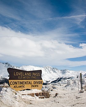
Loveland Pass in late March 2005
|
|
| Elevation | 11,990 ft (3,655 m) |
| Traversed by |
|
| Location | Clear Creek / Summit counties, Colorado, U.S. |
| Range | Front Range |
| Coordinates | 39°39′49″N 105°52′45″W / 39.66361°N 105.87917°WCoordinates: 39°39′49″N 105°52′45″W / 39.66361°N 105.87917°W |
| Topo map | USGS Loveland Pass |
Loveland Pass is a high mountain pass in the western United States, at an elevation of 11,990 feet (3,655 m) above sea level in the Rocky Mountains of north-central Colorado.
It is located on the Continental Divide in the Front Range west of Denver on U.S. Highway 6. The twisty road is considered to be especially treacherous during the winter months. A steep, steady 6.7% grade, along with numerous hairpin turns on either side, make it difficult to snowplow the road regularly.
Loveland is the highest mountain pass in the world that regularly stays open during a snowy winter season. When the Eisenhower Tunnel opened in March 1973, it allowed motorists on Interstate 70 to avoid crossing the pass directly. Trucks that cannot pass through the tunnel (those carrying hazardous materials and those over 13 ft 11 in (4.24 m) in height) must still take US 6 across Loveland Pass, 800 vertical feet (244 m) above the tunnel. The same is true for bicyclists, pedestrians, and those drivers who wish to stop along the road to admire the scenery.
Loveland Ski Area is located at the east side of the pass, and Arapahoe Basin is on the west side. The pass itself is a popular destination for backcountry skiers. Occasionally during the winter, the pass road may be closed by a blizzard and all traffic must use the tunnel, even the normally forbidden HAZMAT-carrying vehicles. In the event of less serious winter storms, chain restrictions are often imposed. At the Loveland Pass parking lot, visitors can access trails to the summits of Mount Sniktau and other nearby mountain peaks.
...
Wikipedia
