Lopez Island

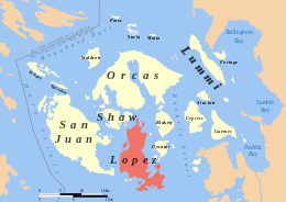
Location of Lopez Island in the San Juans
|
|
| Geography | |
|---|---|
| Location | Pacific Northwest |
| Coordinates | 48°28′44″N 122°53′31″W / 48.47889°N 122.89194°WCoordinates: 48°28′44″N 122°53′31″W / 48.47889°N 122.89194°W |
| Archipelago | San Juan Islands |
| Area | 29.81 sq mi (77.2 km2) |
| Administration | |
|
United States
|
|
| State | Washington |
| County | San Juan County |
| Demographics | |
| Population | 2,177 (2000) |
Lopez Island is the third largest of the San Juan Islands and an unincorporated town in San Juan County, Washington, United States. Lopez Island is 29.81 square miles (77.2 km2) in land area. The 2000 census population was 2,177, though the population swells in the summer, as second homes, rental houses and campsites fill up.
During the Wilkes Expedition, Lopez Island was given the name Chauncey Island, after the American naval commander Isaac Chauncey. When the British reorganized the official admiralty naval charts in 1847, Henry Kellett systematically removed many of Wilkes's names. He renamed the island Lopez, for Gonzalo López de Haro, the Spanish naval officer who was the first European to discover the San Juan Islands archipelago.
The Lopez Island Historical Museum collects and preserves the regional history of Lopez and the San Juan Islands. The museum features artifacts reflecting Lopez's contributions to the maritime, fishing and farming industries. The museum has an extensive archive of local historical documents as well as artifacts depicting life on Lopez Island in the late 19th and early 20th centuries.
Lopez Island is flatter than most of the other major San Juan Islands. It is also the most rural of the larger islands, and has rolling terrain of forest, farmland, and beaches. The island is longest in the north-south direction
This region experiences warm (but not hot) and dry summers, with no average monthly temperatures above 71.6 °F. According to the Köppen Climate Classification system, Lopez Island has a warm-summer Mediterranean climate, abbreviated "Csb" on climate maps.
There are no highways on Lopez Island, and no bridges connecting to the mainland or other islands. The primary means of travel to and from Lopez Island is by ferry. The ferry terminal at the extreme north end of the island. It is the first stop of four on the Washington State Ferries’ San Juan Islands run. A typical sailing from Anacortes takes approximately 40 minutes.
...
Wikipedia
