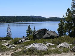
Loon Lake (California)
| Loon Lake Reservoir | |
|---|---|
 |
|
| Location |
Eldorado National Forest El Dorado County, California |
| Coordinates | 38°59′17″N 120°19′52″W / 38.988°N 120.331°WCoordinates: 38°59′17″N 120°19′52″W / 38.988°N 120.331°W |
| Type | Reservoir |
| Primary inflows | Buck-Loon Tunnel |
| Primary outflows | Gerle Creek |
| Catchment area | 5,200 acres (2,100 ha) |
| Basin countries | United States |
| Max. length | 3.5 mi (5.6 km) |
| Water volume | 76,200 acre·ft (94,000,000 m3) |
| Surface elevation | 6,410 ft (1,950 m) |
| References | U.S. Geological Survey Geographic Names Information System: Loon Lake |
Loon Lake Reservoir is a reservoir in the Eldorado National Forest of El Dorado County, California, United States. The 76,200 acre·ft (94,000,000 m3) lake is formed by Loon Lake Dam, completed in 1963 as part of the Upper American River Project by Sacramento Municipal Utility District to conserve spring snow melt runoff for use during the summer and autumn for hydroelectric power production. Loon Lake Dam impounds water at the headwaters of Gerle Creek which, prior to the dam, flowed intermittently through (natural) Loon and Pleasant Lakes. But most of the water now stored in Loon Lake Reservoir arrives from Buck Island Reservoir in the adjacent Rubicon River watershed by way of the Buck-Loon Tunnel. Nearby is Loon Lake Chalet, a popular winter recreation destination. In summer, a boat ramp for water sports and camping are available, but the area is less popular than nearby Union Valley Reservoir and Rubicon Trail.
It is popularly referred to as Loon Lake, although strictly speaking this is the name of the former lake now inundated by the dam. Boaters still refer to the northeast portion of the reservoir as the Pleasant Lake Arm, the portion over the inundated Pleasant Lake.
In 1884, Loon Lake Reservoir was constructed to provide water supply to Georgetown Ridge for mining. It was owned and operated by the Georgetown Divide Water Co. whom used it for irrigation and as a canal system from Gerle Creek to Georgetown Ridge. In 1943, E. F. Sullivan of the Bureau of Reclamation proposed that Loon Lake be used for matters of power generation. In 1948, the Georgetown Divide Public Utility District (GDPUD) applied for appropriative rights from the State of California to appropriate 260,000 acre-feet of water from the American River basin. This was in order to divert water through Loon Lake and Gerle Creek for purposes of irrigation, stock-watering and domestic use.
Originally, the Georgetown Divide Public Utility District (GDPUD) had obtained appropriative water rights from the State Water Resources Control Board. Also, GDPUD exercised pre-1914 rights for diversion of water from several tributaries of Pilot Creek in the South Fork American River. The Georgetown Divide Water Company and other water companies invested that included Sierra Pacific Power Company, Loon Lake Water and Power Company, California Water Company and the Pilot Creek Water Company claimed pre-1914 rights in the South Fork Rubicon and Pilot Creek drainages for years prior to the 20th century. These rights included storage in Loon Lake, diversion from South Fork Rubicon River, Gerle Creek and Pilot Creek and all its tributaries. The water storage in Loon Lake was diverted and re-diverted into a canal system which eventually made its way from the South Fork Rubicon drainage into Pilot Creek drainage.
...
Wikipedia
