Lookout Point
| Caversham | |
|---|---|

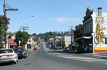
South Road, Caversham, looking west towards the start of the Caversham Valley
|
|

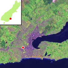
Location of Caversham (shown by red dot) within Dunedin
|
|
| Basic information | |
| Local authority | Dunedin |
| Date established | 1850s |
| Population | 5,058(2006) |
| Surrounds | |
| North | Maryhill |
| Northeast | Mornington |
| East | Kensington |
| Southeast | South Dunedin |
| South | Forbury, Kew |
| Southwest | Calton Hill |
| West | Lookout Point |
| Northwest | Balaclava |
Caversham /ˈkævərʃəm/ is one of the older suburbs of the city of Dunedin, in New Zealand's South Island. It is sited at the western edge of the city's central plain at the mouth of the steep Caversham Valley, which rises to the saddle of Lookout Point. Major road and rail routes south lie nearby; the South Island Main Trunk railway runs through the suburb, and a bypass skirts its main retail area, connecting Dunedin's one-way street system with the Dunedin Southern Motorway. The suburb is linked by several bus routes to its neighbouring suburbs and central Dunedin.
The suburb was founded by wealthy pioneer William Henry Valpy, and its name reflects his family connections with the town of Reading, in the English county of Berkshire. Caversham grew rapidly during the Central Otago Gold Rush of the 1860s because of its location on routes south to the Otago hinterland. By the end of the 19th century, Caversham was heavily industrialised, and its population included many skilled or semi-skilled tradespeople. This, combined with the community's strong Protestant roots, led to the area's generally left-leaning political stance. Caversham's early history has been the subject of the Caversham Project, a major historical and archaeological study by the University of Otago. Caversham was a separate borough until 1904, when it was amalgamated with Dunedin city. It is currently administered as part of the city's South Dunedin ward. At a national level, it is part of the Dunedin South electorate.
...
Wikipedia
