Lonscale Fell
| Lonscale Fell | |
|---|---|

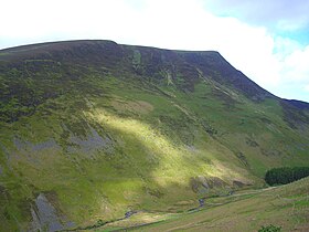
Seen from above the Glenderaterra valley on the path from Threlkeld.
|
|
| Highest point | |
| Elevation | 715 m (2,346 ft) |
| Prominence | c. 50 m |
| Parent peak | Skiddaw Little Man |
| Listing | Wainwright, Hewitt, Nuttal |
| Coordinates | 54°38′05″N 3°06′33″W / 54.63484°N 3.10921°WCoordinates: 54°38′05″N 3°06′33″W / 54.63484°N 3.10921°W |
| Geography | |
| Location | Cumbria, England |
| Parent range | Lake District, Northern Fells |
| OS grid | NY285272 |
| Topo map | OS Landranger 89, 90 OS Explorer OL4 |
Lonscale Fell is a hill in the English Lake District. Its pointed second top is instantly recognisable, standing at the eastern end of the Skiddaw massif. The fell is easily climbed from Keswick or from Skiddaw House to the north. Although now primarily a sheep pasture, it once saw considerable mining activity beneath the long eastern wall of crag.
The long south east ridge of Skiddaw descends over Little Man and Jenkin Hill to the depression of Flag Pots. Beyond this is the final upthrust of Lonscale Fell before the craggy descent to the Glenderaterra Beck,
The southern flanks fall gently over acres of sheep pasture in the manner of the Skiddaw range. At the base of the slope is the wooded valley of Whit Beck, separating Lonscale Fell from the east ridge of Latrigg. Here also is Lonscale, the farm which has given its name to the fell. Whit Beck is a tributary of the Glenderaterra, a stream which forms the eastern boundary of Lonscale Fell. This flows due south from Skiddaw Forest between the Skiddaw massif and Blencathra, before joining the River Greta and running on through Keswick. The eastern face of the fell above the Glenderaterra is a mile long scarp of crags, a singular feature in the Skiddaw range.
To the north of the fell is Skiddaw Forest. Confusingly this forest contains no trees, —other than the windbreak of Skiddaw House — but is a marshy upland area at around 1,300 ft surrounded on all sides by higher fells. Three streams flow from Skiddaw Forest, dividing the Northern Fells into three sectors. Dash Beck runs north west, the River Caldew north east and the River Glenderaterra south. The single building in Skiddaw Forest is Skiddaw House, which has variously seen service as a shepherds' bothy and a Youth Hostel.
The northern boundary of Lonscale Fell is Salehow Beck, a tributary of the River Caldew, its waters bound for the Solway Firth by way of Carlisle. Beyond the river is Great Calva, the first of the Back o'Skiddaw fells. The feeders of Salehow Beck and Whit Beck flow from the col of Flag Pots, completing the western boundary.
...
Wikipedia

