Longitude (book)

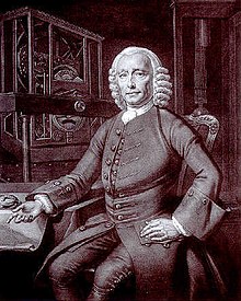
Behind John Harrison stands his 1726 pendulum clock while his H4 watch lies to his right on the table
|
|
| Author | Dava Sobel |
|---|---|
| Genre | Popular Science |
| Publisher | Walker |
|
Publication date
|
1995 (reprinted 1996 and 2005) |
| Pages | 191 |
| ISBN | |
| OCLC | 183660066 |
Longitude: The True Story of a Lone Genius Who Solved the Greatest Scientific Problem of His Time is a best-selling book by Dava Sobel about John Harrison, an 18th-century clockmaker who created the first clock (chronometer) sufficiently accurate to be used to determine longitude at sea—an important development in navigation. The book was made into a television series entitled Longitude. In 1998, The Illustrated Longitude was published, supplementing the earlier text with 180 images of characters, events, instruments, maps and publications.
Determining longitude on land was fairly easy compared to the task at sea. A stable surface to work from, a comfortable location to live in while performing the work and the ability to repeat determinations over time made for great accuracy. Whatever could be discovered from solving the problem at sea would only improve the determination of longitude on land.
Determining latitude was relatively easy in that it could be found from the altitude of the sun at noon with the aid of a table giving the sun's declination for the day. For longitude, early ocean navigators had to rely on dead reckoning. This was inaccurate on long voyages out of sight of land and these voyages sometimes ended in tragedy as a result.
In order to avoid problems with not knowing one's position accurately, navigators have, where possible, relied on taking advantage of their knowledge of latitude. They would sail to the latitude of their destination, turn toward their destination and follow a line of constant latitude. This was known as running down a westing (if westbound, easting otherwise). This prevented a ship from taking the most direct route (a great circle) or a route with the most favourable winds and currents, extending the voyage by days or even weeks. This increased the likelihood of short rations,scurvy or starvation leading to poor health or even death for members of the crew and resultant risk to the ship.
Errors in navigation have also resulted in shipwrecks. Motivated by a number of maritime disasters attributable to serious errors in reckoning position at sea, particularly spectacular disasters such as the Scilly naval disaster of 1707 which took Admiral Sir Cloudesley Shovell and his fleet, the British government established the Board of Longitude in 1714.
...
Wikipedia
