Longa Island
| Gaelic name | Longa |
|---|---|
| Norse name | Possibly Long-øy |
| Meaning of name | Old Norse 'ship Island' |
| Location | |
|
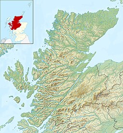
Longa Island shown within Highland Scotland
|
|
| OS grid reference | NG736776 |
| Coordinates | 57°43′N 5°48′W / 57.72°N 5.8°W |
| Physical geography | |
| Island group | Highland |
| Area | 126 hectares (0.49 sq mi) |
| Area rank | 132 |
| Highest elevation | Druim am Eilean 70 metres (230 ft) |
| Administration | |
| Sovereign state | United Kingdom |
| Country | Scotland |
| Council area | Highland Council |
| Demographics | |
| Population | 0 |
| References | |
Longa Island (Gaelic: Longa) is a small uninhabited island at the mouth of Gairloch on the west coast of Scotland.
The island is mainly sandstone covered with grass and heather.
There was a small fishing community in early in the 19th century; the island had become deserted by the latter part.
Longa Island, across the Caolas Beag
Shags on Sron na Caillich
Unmapped Sea Cave Below An Raon
Camus na Rainich
Coordinates: 57°43′54″N 5°48′9″W / 57.73167°N 5.80250°W
...
Wikipedia

