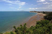
Long Bay, New Zealand
| Long Bay | |
|---|---|
 |
|
| Basic information | |
| Local authority | Auckland Council |
| Population | 954 (2006) |
| Surrounds | |
| Northeast | (Hauraki Gulf) |
| East | (Hauraki Gulf) |
| South | Torbay |
| Southwest | Torbay Heights |
| Northwest | Okura |
Long Bay is a suburb of North Shore, part of the Auckland metropolitan area in northern New Zealand. The population was 954 in the 2006 Census, an increase of 210 from 2001.
The coastline is occupied by the Long Bay Regional Park, and the shoreline is in Long Bay-Okura Marine Reserve, which opened in 1995. The beach is sandy and swimming is safe. It offers forest walks and scenic cliffs. This beach has low tide water. Smaller beaches to the north, accessible except at high tide, are used by nudists. The Vaughan Homestead is a historic house at the north end of the beach. It is open fortnightly to the public.
A small Māori community of Ngāti Kahu lived at Long Bay, then called Te Oneroa, until the 1850s. The Vaughan family bought 600 hectares and farmed sheep from 1862 until selling their land to the Auckland Regional Council in 1965 to form the park. A gun emplacement was built on the coast north of the park to defend against invasion by Japanese forces during the Second World War. Remnants of the emplacement still exist.
Areas of farmland above Long Bay Regional Park were protected from development by an Environment Court ruling in July 2008. There is significant development of housing as of 2014 under the Auckland Council's Unitary Plan.
Long Bay College is a secondary (years 9-13) school with a roll of 1562. The college celebrated its 25th jubilee in 2000. Long Bay School is a contributing primary (years 1-6) school with a roll of 348. Both schools are coeducational and have a decile rating of 10.
Coordinates: 36°41′05″S 174°44′57″E / 36.68472°S 174.74917°E
...
Wikipedia
