Lombenben
| Lombenben | |
|---|---|
| Highest point | |
| Elevation | 1,496 m (4,908 ft) |
| Coordinates | 15°23′24.21″S 167°49′49.63″E / 15.3900583°S 167.8304528°ECoordinates: 15°23′24.21″S 167°49′49.63″E / 15.3900583°S 167.8304528°E |
| Geography | |
| Location | Ambae Island, Vanuatu |
| Geology | |
| Mountain type | Shield volcano |
| Last eruption | 2006 |
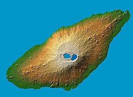
Lombenben is a 1,496 meter high shield volcano on the island of Ambae in Vanuatu. It rises about 3,000 meters above sea level. Other names for this volcano include Ambae volcano, Aoba, and Omba. Occasionally, the name of the volcano is confused with the name of its crater (Manaro).
The mountain is one of the most dangerously active volcanoes in the world; its last eruption was recorded in 2006. There are three warm freshwater crater lakes on the volcano, near its peak:Manaro Ngoru, Vui (Voui) and Manaro Lakua. Vui, the inner crater, alone contains 50 million cubic metres of water. Previously, up to 5,000 people living near the volcano have had to be evacuated for their safety.
...
Wikipedia

