Lockeridge
| Lockeridge | |
|---|---|
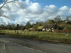
 Lockeridge Dene, a conservation area in the village |
|
| Lockeridge shown within Wiltshire | |
| Population | 291 (in 1991) |
| OS grid reference | SU148678 |
| • London | 74 miles (119 km) E |
| Civil parish | |
| Unitary authority | |
| Ceremonial county | |
| Region | |
| Country | England |
| Sovereign state | United Kingdom |
| Post town | Marlborough |
| Postcode district | SN8 |
| Dialling code | 01672 |
| Police | Wiltshire |
| Fire | Dorset and Wiltshire |
| Ambulance | South Western |
| EU Parliament | South West England |
| UK Parliament | |
| Website | Parish |
Lockeridge (pop. approximately 290) is a village in Wiltshire, England. It lies at the edge of the West Woods in the Kennet Valley, 2.9 miles (4.7 km) west of Marlborough, 3.1 miles (5.0 km) east of Avebury and 10.5 miles (16.9 km) south of Swindon. It is 0.6 miles (0.97 km) south of the A4 road which was historically the main route from London to the west of England.
Lockeridge Dene is a hamlet immediately southwest of the village.
Lockeridge and its surroundings have provided evidence of Stone and Bronze Age activity in the area. Field enclosures close to the village indicate Roman occupation, whilst the village itself appears in the Domesday Book of 1086.
Lockeridge today forms an agricultural and commuter community with no local industry. The community is served by a village pub, the Who'd a Thought It, but has no other services.
The area has extensive evidence of Neolithic settlement and a Bronze Age burial site was discovered behind the school in the 19th century. Field enclosures on White Hill (a ridge above the village) provide evidence of Roman occupation probably linked to the nearby fortress town of Cunetio. One possible derivation of the name is from the Old English composite word loc(a)-hrycg meaning "a ridge marked by enclosure(s)".
At the time of the Domesday Book of 1086, Lockeridge was owned by Durand of Gloucester and is described as follows: Durand himself holds LOCKERIDGE. Almær held it TRE, and it paid geld for 2 hides. There is land for 1 plough. Of this 1 hide is in demesne. There is 1 villan and 2 bordars with 1 slave, and 1-acre (4,000 m2) of meadow, and 12 acres (4.9 ha) of pasture and 6 acres (2.4 ha) of woodland. It was worth 40s ; now 30s. These two late Anglo-Saxon estates are held to be linked to the cluster of houses at Lockeridge Dene at the southern end of the village, and the eighteenth-century Lockeridge House at the northern end. Lockeridge House is adjacent to Piper's Lane, remnant of a Roman road.
...
Wikipedia

