Little River (Mendocino County)
| Little River | |
| stream | |
|
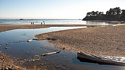
The mouth of the Little River, in Van Damme State Park
|
|
| Country | United States |
|---|---|
| State | California |
| Region | Mendocino County |
| Source | Mathison Peak |
| - location | 5 miles (8 km) east of Little River, California |
| - coordinates | 39°16′16″N 123°41′57″W / 39.27111°N 123.69917°W |
| Mouth | Pacific Ocean |
| - location | Little River, California |
| - elevation | 0 ft (0 m) |
| - coordinates | 39°16′27″N 123°47′29″W / 39.27417°N 123.79139°WCoordinates: 39°16′27″N 123°47′29″W / 39.27417°N 123.79139°W |
Little River (Wiyot: p'lèt kacamale "rocks-small" ) is a 5.8-mile-long (9.3 km) westward-flowing stream in Mendocino County, California which empties into the Pacific Ocean in Van Damme State Park near the town of Little River, California. Big River enters the Pacific about 2 miles (3 km) farther north.
Tributaries include Laguna Creek, North Fork Little River, Two Log Creek, Russell Brook, and Rice Creek.
...
Wikipedia

