Little Pine State Park
| Little Pine State Park | |
| Pennsylvania State Park | |
|
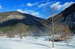
a view of the park in winter
|
|
| Named for: Little Pine Creek | |
| Country | United States |
|---|---|
| State | Pennsylvania |
| County | Lycoming |
| Township | Cummings |
| Location | |
| - elevation | 710 ft (216 m) |
| - coordinates | 41°21′22″N 77°21′19″W / 41.35611°N 77.35528°WCoordinates: 41°21′22″N 77°21′19″W / 41.35611°N 77.35528°W |
| Area | 2,158 acres (873 ha) |
| Founded | 1937 |
| Management | Pennsylvania Department of Conservation and Natural Resources |
| Visitation | 87,418 |
| IUCN category | III - Natural Monument |
| Website: Little Pine State Park | |
Little Pine State Park is a Pennsylvania state park on 2,158 acres (873 ha) in Cummings Township, Lycoming County, Pennsylvania in the United States. Little Pine State park is along 4.2 miles (6.8 km) of Little Pine Creek, a tributary of Pine Creek, in the midst of the Tiadaghton State Forest. A dam on the creek has created a lake covering 94 acres (38 ha) for fishing, boating, and swimming. The park is on Pennsylvania Route 4001, 4 miles (6.4 km) northeast of the unincorporated village of Waterville or 8 miles (13 km) southwest of the village of English Center. The nearest borough is Jersey Shore, Pennsylvania, about 15 miles (24 km) south at the mouth of Pine Creek on the West Branch Susquehanna River.
Humans have lived in what is now Pennsylvania since at least 10,000 BC. The first settlers were Paleo-Indian nomadic hunters known from their stone tools. The hunter-gatherers of the Archaic period, which lasted locally from 7000 to 1000 BC, used a greater variety of more sophisticated stone artifacts. The Woodland period marked the gradual transition to semi-permanent villages and horticulture, between 1000 BC and 1500 AD. Archeological evidence found in the state from this time includes a range of pottery types and styles, burial mounds, pipes, bows and arrows, and ornaments.
...
Wikipedia


