Lilly, Pennsylvania
| Lilly, Pennsylvania | |
|---|---|
| Borough | |

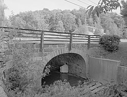
The Lilly Bridge, a historic site in the borough
|
|
| Coordinates: 40°25′30″N 78°37′14″W / 40.42500°N 78.62056°WCoordinates: 40°25′30″N 78°37′14″W / 40.42500°N 78.62056°W | |
| Country | United States |
| State | Pennsylvania |
| County | Cambria |
| Settled | 1806 |
| Incorporated | 1883 |
| Government | |
| • Type | Borough council |
| • Mayor | Michael Eckenrode |
| Area | |
| • Total | 0.50 sq mi (1.30 km2) |
| • Land | 0.50 sq mi (1.30 km2) |
| Elevation | 1,904 ft (580 m) |
| Population (2010) | |
| • Total | 968 |
| • Density | 1,924/sq mi (742.9/km2) |
| Time zone | Eastern (EST) (UTC-5) |
| • Summer (DST) | EDT (UTC-4) |
| ZIP code | 15938 |
| Area code(s) | 814 |
| Website | lillyboro |
Lilly is a borough in Cambria County, Pennsylvania, United States. It is part of the Johnstown, Pennsylvania Metropolitan Statistical Area. The population was 968 at the 2010 census.
The Lilly Bridge was listed on the National Register of Historic Places in 1988.
Lilly is located in eastern Cambria County at 40°25′30″N 78°37′14″W / 40.42500°N 78.62056°W (40.425000, -78.620434), in the valley of the Little Conemaugh River near its headwaters. Pennsylvania Route 53 passes through the borough, leading north 2 miles (3 km) to U.S. Route 22 near Cresson.
According to the United States Census Bureau, Lilly has a total area of 0.50 square miles (1.3 km2), all of it land.
As of the census of 2000, there were 948 people, 407 households, and 269 families residing in the borough. The population density was 1,952.4 people per square mile (747.0/km²). There were 439 housing units at an average density of 904.1 per square mile (345.9/km²). The racial makeup of the borough was 99.47% White, 0.21% Native American, 0.11% Asian, 0.11% Pacific Islander, and 0.11% from two or more races.
...
Wikipedia

