Lifta
| Lifta | |
|---|---|

Former Arab village of Lifta
|
|
| Arabic | لفتا |
| Name meaning | Lifta, personal name |
| Also spelled | Lefta |
| Subdistrict | Jerusalem |
| Coordinates | 31°47′43″N 35°11′47″E / 31.79528°N 35.19639°ECoordinates: 31°47′43″N 35°11′47″E / 31.79528°N 35.19639°E |
| Palestine grid | 168/133 |
| Population | 2,958 (1948) |
| Area | 8,743 dunams 8.7 km² |
| Date of depopulation | January 1948 |
| Cause(s) of depopulation | Military assault by Yishuv forces |
| Current localities | Western suburb of Jerusalem |
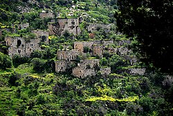
Lifta (Arabic: لفتا; Hebrew: מי נפתוח Mei Neftoach, lit. spring of the corridor) was a Palestinian Arab village on the outskirts of Jerusalem. The population was driven out during the Arab-Jewish hostilities of 1947/48 and the efforts to relieve the Siege of Jerusalem (1948). Mainly intact, it is located on the spot of the Tanachic village "Nephtoah", on a hillside between the western entrance to Jerusalem and the Romema neighbourhood. In 2012, plans to rebuild the village as an upscale neighborhood were rejected by the Jerusalem District Court.
The site was populated since ancient times; "Nephtoah" (Hebrew: נפתח) is mentioned in the Hebrew Bible as the border between the Israelite tribes of Judah and Benjamin. It was the northernmost demarcation point of the territory of the Tribe of Judah. The Romans and Byzantines called it Nephtho, and the Crusaders referred to it as Clepsta. The remains of a court-yard home from the Crusader period remains in the centre of the village.
In 1596, Lifta was a village in the Ottoman Empire, nahiya (subdistrict) of Jerusalem under the liwa' (district) of Jerusalem, and it had a population of 396. It paid taxes on wheat, barley, olives, fruit orchards and vineyards.
...
Wikipedia

