Liedertswil
| Liedertswil | ||
|---|---|---|
 |
||
|
||
| Coordinates: 47°24′N 7°43′E / 47.400°N 7.717°ECoordinates: 47°24′N 7°43′E / 47.400°N 7.717°E | ||
| Country | Switzerland | |
| Canton | Basel-Landschaft | |
| District | Waldenburg | |
| Area | ||
| • Total | 1.94 km2 (0.75 sq mi) | |
| Elevation | 629 m (2,064 ft) | |
| Population (Mar 2016) | ||
| • Total | 163 | |
| • Density | 84/km2 (220/sq mi) | |
| Postal code | 4436 | |
| SFOS number | 2890 | |
| Surrounded by | Oberdorf, Reigoldswil, Titterten, Waldenburg | |
| Website |
www SFSO statistics |
|
Liedertswil (Swiss German: Tschoppehof) is a municipality in the district of Waldenburg in the canton of Basel-Country in Switzerland.
Liedertswil is first mentioned in 1194 as Liedirwilre.
Liedertswil has an area, as of 2009[update], of 1.94 square kilometers (0.75 sq mi). Of this area, 0.72 km2 (0.28 sq mi) or 37.1% is used for agricultural purposes, while 1.13 km2 (0.44 sq mi) or 58.2% is forested. Of the rest of the land, 0.1 km2 (25 acres) or 5.2% is settled (buildings or roads).
Of the built up area, housing and buildings made up 2.1% and transportation infrastructure made up 3.1%. Out of the forested land, 53.1% of the total land area is heavily forested and 5.2% is covered with orchards or small clusters of trees. Of the agricultural land, 2.1% is used for growing crops and 24.7% is pastures and 9.3% is used for alpine pastures.
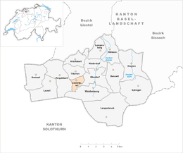
The municipality is located in the Waldenburg district, at the entrance to the Waldenburger valley into the Reigoldswiler valley.
The blazon of the municipal coat of arms is Or, three Houses in pale Argent roofed Azure doored and windowed Sable.
Liedertswil has a population (as of March 2016[update]) of 163. As of 2008[update], 2.6% of the population are resident foreign nationals. Over the last 10 years (1997–2007) the population has changed at a rate of 5.9%.
Most of the population (as of 2000[update]) speaks German (148 or 98.0%) with the rest speaking French
...
Wikipedia


