Lexington–Fayette Metropolitan Statistical Area
| Lexington–Fayette Metropolitan Area | |
|---|---|
| MSA | |
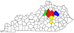
 Map of the Lexington–Fayette–Frankfort–Richmond CSA, with the Lexington–Fayette Metropolitan Statistical Area highlighted in red. |
|
| Country |
|
| State |
|
| Largest city | Lexington |
| Area | |
| • MSA | 1,484.07 sq mi (3,843.7 km2) |
| Population (2012) | |
| • Total | 485,023(106th) |
| Time zone | EST (UTC-5) |
| • Summer (DST) | EDT (UTC-4) |
| Area code(s) | 859 |
The Lexington–Fayette Metropolitan Statistical Area is the 106th-largest Metropolitan Statistical Area (MSA) in the United States. It was originally formed by the United States Census Bureau in 1950 and consisted solely of Fayette County until 1980 when surrounding counties saw increases in their population densities and the number of their residents employed within Lexington–Fayette, which led to them meeting Census criteria to be added to the MSA.
The Lexington–Fayette MSA is the primary MSA of the Lexington–Fayette–Richmond–Frankfort combined statistical area which includes the Micropolitan Statistical Areas of Frankfort (Franklin and Anderson counties), Mount Sterling (Montgomery, Bath, and Menifee counties), and Richmond–Berea (Madison and Rockcastle counties). The Lexington–Fayette–Frankfort–Richmond combined statistical area has a July 1, 2012 Census Bureau estimated population of 703,271.
...
Wikipedia
