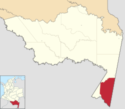
Leticia, Colombia
| Leticia | |||
|---|---|---|---|
|
|||
 Location map of the municipality and town of Leticia in the Department of Amazonas. |
|||
| Location in Colombia | |||
| Coordinates: 4°12′19″S 69°55′58″W / 4.20528°S 69.93278°W | |||
| Country |
|
||
| Department | Department of Amazonas | ||
| Foundation | 1867 | ||
| Government | |||
| • Mayor | José Ignacio Lozano Guzmán | ||
| Area | |||
| • Total | 5,968 km2 (2,304 sq mi) | ||
| Elevation | 96 m (315 ft) | ||
| Population (2005) | |||
| • Total | 32,450 | ||
| • Density | 5.4/km2 (14/sq mi) | ||
| Demonym(s) | Leticiano | ||
| Area code(s) | 57 + 8 | ||
| Climate | Af | ||
| Website | Official website | ||
| Leticia | ||||||||||||||||||||||||||||||||||||||||||||||||||||||||||||
|---|---|---|---|---|---|---|---|---|---|---|---|---|---|---|---|---|---|---|---|---|---|---|---|---|---|---|---|---|---|---|---|---|---|---|---|---|---|---|---|---|---|---|---|---|---|---|---|---|---|---|---|---|---|---|---|---|---|---|---|---|
| Climate chart () | ||||||||||||||||||||||||||||||||||||||||||||||||||||||||||||
|
||||||||||||||||||||||||||||||||||||||||||||||||||||||||||||
|
||||||||||||||||||||||||||||||||||||||||||||||||||||||||||||
| J | F | M | A | M | J | J | A | S | O | N | D |
|
209
32
22
|
181
32
22
|
205
32
22
|
200
32
22
|
219
31
22
|
137
31
22
|
101
31
21
|
116
32
21
|
120
32
22
|
156
32
22
|
167
32
22
|
164
32
22
|
| Average max. and min. temperatures in °C | |||||||||||
| Precipitation totals in mm | |||||||||||
| Source: MSN Weather | |||||||||||
| Imperial conversion | |||||||||||
|---|---|---|---|---|---|---|---|---|---|---|---|
| J | F | M | A | M | J | J | A | S | O | N | D |
|
8.2
90
72
|
7.1
90
72
|
8.1
90
72
|
7.9
90
72
|
8.6
88
72
|
5.4
88
72
|
4
88
70
|
4.6
90
70
|
4.7
90
72
|
6.1
90
72
|
...
| |


