Lesser Cursus
|
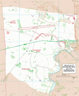
Map showing the Cursus within the Stonehenge section of the Stonehenge and Avebury World Heritage Site
|
|
| Alternate name | Greater Cursus and Lesser Cursus |
|---|---|
| Region | Wiltshire |
| Coordinates | 51°11′10″N 1°49′34″W / 51.186°N 1.826°WCoordinates: 51°11′10″N 1°49′34″W / 51.186°N 1.826°W |
| Type | Cursus |
| History | |
| Periods | Neolithic |
| Site notes | |
| Excavation dates | 1947, 2007 |
| Archaeologists | John FS Stone, Stonehenge Riverside Project |
| Condition | Excellent |
| Public access | Yes |
| Website | National Trust |
| Designated | 1986 |
| Reference no. | 373 |
| Designated | 1952 |
| Reference no. | 1009132 |
The Stonehenge Cursus (sometimes known as the Greater Cursus) is a large Neolithic cursus monument on Salisbury plain, near to Stonehenge in Wiltshire, England. It is roughly 3 kilometres (1.9 mi) long and between 100 metres (330 ft) and 150 metres (490 ft) wide. Excavations in 2007 dated the construction of the earthwork to between 3630 and 3375 BCE, several hundred years before the earliest phase of Stonehenge in 3000 BC. The cursus, along with adjacent barrows and the nearby 'Lesser Cursus' are part of the National Trust's Stonehenge Landscape property, and is within the Stonehenge and Avebury World Heritage Site.
Cursus comes from the Latin for 'racecourse'. Early antiquarians who first discovered cursus believed them to be Roman racing tracks.
Radiocarbon dating of a red deer antler pick discovered at the bottom of the western terminal ditch suggests that the Stonehenge Cursus was first constructed between 3630 and 3375 BCE. It is just under 3 km long, and is roughly 100m wide. Because of a slight difference in the alignment of its north and south ditches, it widens to a point nearly 150m near its western end. It is roughly aligned east-west and is oriented toward the sunrise on the spring and autumn equinoxes. There is a (later) Bronze Age round barrow inside the western end of the enclosure, and a large Neolithic long barrow was constructed at its east terminal. The Stonehenge Riverside Project excavated the remains of the long barrow in 2008 to determine if the barrow predated, or was contemporary with the cursus itself. The ditches of the cursus are not uniform and vary in width and depth. The eastern ditch is fairly shallow, as is the southern ditch – being only 0.75m deep and 1.8m wide at the top. At the western terminal, the ditch is 2m deep and 2.75m wide.
...
Wikipedia

