Leonard Stanley
| Leonard Stanley | |
|---|---|
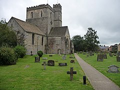
 St Swithuns church |
|
| Leonard Stanley shown within Gloucestershire | |
| Population | 1,466 |
| OS grid reference | SO 80388 03653 |
| Shire county | |
| Ceremonial county | |
| Region | |
| Country | England |
| Sovereign state | United Kingdom |
| Post town | Stroud |
| Postcode district | GL10 |
| Dialling code | 01453 |
| Police | Gloucestershire |
| Fire | Gloucestershire |
| Ambulance | South Western |
| EU Parliament | South West England |
| UK Parliament | |
Leonard Stanley is a small village on the outskirts of Stonehouse in Gloucestershire. Approximately 2.5 miles from Stroud it is located east of the River Severn and North East of the Bristol channel. The surrounding land use around Leonard Stanley is primarily agricultural, however, Leonard Stanley does contain a small cluster of residential and urban usage.
A Gloucestershire village of 600 homes nestling beneath the Cotswold escarpment, overlooking the Severn Vale. Originally a Saxon village, Leonard Stanley became a busy weaving and agricultural centre, with shops and cottage industries, until the 1970s. In recent years the village profile has changed to that of a dormitory village, with families mostly commuting to the surrounding towns and cities. The community however still has a heart and this website celebrates the wealth of rural life that still exists, and the people who play a part in it. Leonard Stanley is situated seven miles from the city of Gloucester and thirty miles from Bristol. It is easily accessible by road with Junction 13 of the M5 motorway just three miles away. There are railway stations at Stroud, Stonehouse and Cam and international airports at Bristol, Cardiff & Birmingham.
What once had been described as a market town, "Leonard Stanley with its fairs and its weekly market, for some time the only one in the hundred, was formerly a centre of trade; it was described as a market-town in 1650. It declined in importance after the 17th century, and the beginning of the decline was later associated with the fire of 1686." This later declined.
The parish church of St Swithun dates from the 12th century and is a grade I listed building. The nature reserve of Five Acre Grove lies close to the village and is designated a Key Wildlife Site (KWS).
Text with reference to Leonard Stanley through Christian writing, "It was with difficulty we made our way through this most loving people, and returned amidst their prayers and blessings to Ebly. Here I expounded the second lesson for two hours, and received strength and faith to plead the promise of the Father. A good old Baptist pressed me to preach at Stanley, in my way to Bristol."
Leonard Stanley is represented by the county councillor for Dursley division and the two district councillors for The Stanleys ward on Stroud District Council.
In 1870-72, John Marius Wilson's Imperial Gazetteer of England and Wales described Leonard Stanley.
LEONARD-STANLEY, or STANLEY-ST. LEONARDS, a village and a parish in Stroud district, Gloucester. The village stands 1 mile E by S of Frocester r. station, 1½ S by E of Stonehouse r. station, and 3½ SW by W of Stroud; was once a market-town; was nearly all destroyed by fire in 1686; and has a post office under Stonehouse, and a fair on 20 July. The parish contains also the hamlet of Downton, and includes the detached tract of Lorridge. Acres, 1,070. Real property, £4,188; of which £655 are in railways.
...
Wikipedia

