Leisure City, Florida
| Leisure City, Florida | |
|---|---|
| CDP | |
 Location in Miami-Dade County and the state of Florida |
|
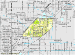
 U.S. Census Bureau map showing CDP boundaries |
|
| Coordinates: 25°29′39″N 80°26′10″W / 25.49417°N 80.43611°WCoordinates: 25°29′39″N 80°26′10″W / 25.49417°N 80.43611°W | |
| Country |
|
| State |
|
| County | Miami-Dade |
| Area | |
| • Total | 3.4 sq mi (8.8 km2) |
| • Land | 3.4 sq mi (8.8 km2) |
| • Water | 0 sq mi (0 km2) |
| Elevation | 7 ft (2 m) |
| Population (2000) | |
| • Total | 22,152 |
| • Density | 6,515.3/sq mi (2,517.3/km2) |
| Time zone | Eastern (EST) (UTC-5) |
| • Summer (DST) | EDT (UTC-4) |
| ZIP codes | 33030, 33033 |
| Area code(s) | 305 |
| FIPS code | 12-39950 |
| GNIS feature ID | 0285449 |
Leisure City is a census-designated place (CDP) in Miami-Dade County, Florida, United States. The population was 22,152 at the 2000 census. Leisure City is most notable for housing the Coral Castle Museum within its official boundaries.
Leisure City is located at 25°29′39″N 80°26′10″W / 25.49417°N 80.43611°W (25.494037, -80.436229).
According to the United States Census Bureau, the CDP has a total area of 3.4 square miles (8.8 km2), of which, 3.4 square miles (8.8 km2) of it is land and 0.04 square miles (0.10 km2) of it (0.58%) is water.
Leisure City borders the communities of Naranja, Homestead, and Redland.
As of the census of 2000, there were 22,152 people, 6,063 households, and 5,044 families residing in the CDP. The population density was 6,490.0 people per square mile (2,508.2/km²). There were 6,615 housing units at an average density of 1,938.0/sq mi (749.0/km²). The racial makeup of the CDP was 65.03% White (15.2% were Non-Hispanic Whites,) 18.00% African American, 0.20% Native American, 0.84% Asian, 0.03% Pacific Islander, 11.42% from other races, and 4.48% from two or more races. Hispanic or Latino of any race were 65.30% of the population.
...
Wikipedia
