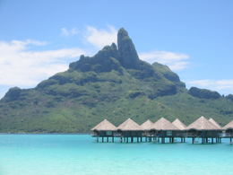
Leeward Islands (Society Islands)
| Native name: Îles Sous-le-vent (French) Fenua Raro Mata’i (Tahitian) |
|
|---|---|

|
|
| Geography | |
| Location | Pacific Ocean |
| Coordinates | Coordinates: 17°32′S 149°50′W / 17.533°S 149.833°W |
| Archipelago | Society Islands |
| Total islands | 9 |
| Major islands | Raiatea, Bora Bora, Huahine, Tahaa |
| Area | 395 km2 (153 sq mi) |
| Highest elevation | 1,017 m (3,337 ft) |
| Highest point | Tefatua |
| Administration | |
|
France
|
|
| Overseas collectivity | French Polynesia |
| Largest settlement | Uturoa (pop. 8,735 urban) |
| Demographics | |
| Population | 33,184 (Aug. 2007 census) |
| Pop. density | 84 /km2 (218 /sq mi) |
The Leeward Islands (French: Îles Sous-le-vent; Tahitian: Fenua Raro Mata’i, literally "Islands Under-the-Wind") are the western part of the Society Islands in French Polynesia, an overseas collectivity of France in the South Pacific. They lie south of the Line Islands (part of Kiribati), east of the Cooks and north of the Austral Islands (also part of French Polynesia). Their area is 395 km² with a population of over 33,000. The islands to the west comprise a three atoll group: Manuae (a.k.a. Scilly Atoll), Motu One atoll (a.k.a. Bellinghausen), lying most northerly of the Leeward Islands, and to the southeast Maupihaa atoll (a.k.a. Mopelia). More to the east lies a mainly high island cluster consisting of Maupiti (Tahitian name: Maurua), Tupai atoll, Bora Bora (Tahitian name: Vava'u), the most known of the Leeward Islands in the western world due to its World War II United States naval base and subsequent tourism industry, Tahaa (Tahitian name: Uporu), lying just north of the largest island of the group, Raiatea (Tahitian names: Hava'i, Ioretea) which possesses the largest city and local capital of the Leeward Islands, namely Uturoa, as well as the highest elevation, the just over 1,000 m mount Tefatua, and finally the easternmost island of the group, Huahine (Tahitian name: Mata'irea) which at high tide is divided into two: Huahine Nui ("big Huahine") to the north and Huahine Iti ("small Huahine") to the south.
...
Wikipedia

