Leckhampstead, Berkshire
| Leckhampstead | |
|---|---|
 The ecclesiastical parish church in the Church of England, to St James, built c.1858–60. |
|
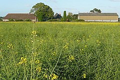
 Manor Farm House, various dates from the 17th century, outbuildings and cultivated fields. |
|
| Leckhampstead shown within Berkshire | |
| Area | 7.13 km2 (2.75 sq mi) |
| Population | 343 (2011 census) |
| • Density | 48/km2 (120/sq mi) |
| Civil parish |
|
| Unitary authority | |
| Ceremonial county | |
| Region | |
| Country | England |
| Sovereign state | United Kingdom |
| Post town | Newbury |
| Postcode district | RG20 |
| Dialling code | 01635 |
| Police | Thames Valley |
| Fire | Royal Berkshire |
| Ambulance | South Central |
| EU Parliament | South East England |
| UK Parliament | |
Leckhampstead is a village and civil parish in West Berkshire, England in the North Wessex Downs.
Leckhampstead Thicket has a high proportion of its buildings that are thatched cottages and has a chapel, dated 1874, that is one of few active 'Primitive Methodist' chapels. A road and boundary stone in Leckhampstead, the Hangman's Stone and Hangman's Stone Lane, are named after a telling of a man who roped and carried a sheep from a farm in Leckhampstead around his neck (to steal it) but which strangled him after he stopped and slept. After a long hiatus the area returned to full village status in 1864. Its hamlet of Hill Green has six listed buildings and the amenities of the village include a public house, church and village hall.
The village is in the North Wessex Downs at all points a few miles north of the M4 motorway. It has within 400 metres east of its main residential area, which is a linear development, the B road between Newbury (7 miles (11 km) SSE) and Wantage (8 miles (13 km) NNW). Most of the land is agricultural with a few woodlands, particularly along the northern border where elevation exceeds 170m above sea level. There are several winterbournes that flow in the winter in this area. The land being on considerable proportions of chalk in its soil most of the natural drainage is subterranean, which is borne out by the detailed land survey by the Office of National Statistics having been unable to identify any water at the surface. A village of more than 2500 people and with more amenities is concentrated three miles south-east at Chieveley.
...
Wikipedia

