Laramie Formation
| Laramie Formation Stratigraphic range: Upper Cretaceous |
|
|---|---|

|
|
| Type | Geological formation |
| Underlies | Arapahoe Formation |
| Overlies | Fox Hills Formation |
| Thickness | 200-400 ft (60-120 m) |
| Lithology | |
| Primary | Sandstone, mudstone, clay, coal |
| Location | |
| Region |
|
| Country |
|
| Type section | |
| Named by | Clarence King |
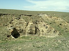
The Laramie Formation is a geologic formation of Late Cretaceous (Maastrichtian) age, named by Clarence King in 1876 for exposures in northeastern Colorado, in the United States. It was deposited on a coastal plain and in coastal swamps that flanked the Western Interior Seaway. It contains coal, clay and uranium deposits, as well as plant and animal fossils, including dinosaur remains.
The Laramie Formation is exposed around the edges of the Denver Basin and ranges from 400–500 feet (120–150 m) on the western side of the basin, and 200–300 feet (60–90 m) thick on the eastern side. It rests conformably on the Fox Hills Sandstone and unconformably underlies the Arapahoe Conglomerate. The formation can be divided into an unnamed lower member containing bedded sandstone, clay and coal; and an unnamed upper member composed predominately of 90 to 190 m of drab-colored mudstone, some sandstone, and thin coal beds. Nodular ironstone concretions occur in the mudstones that contain plant remains. Some of the material in the sandstones originated from silicic volcanoes far to the west.
The coal and clay deposits of the Laramie Formation were once economically important. Clay mining began in the Golden, Colorado area in 1877 and continued until the mid-twentieth century. Most of the clay was used to make bricks and tiles for building construction.
...
Wikipedia
