Langley Field
| Langley Air Force Base | |
|---|---|
| Part of Air Combat Command (ACC) | |
| Hampton, Virginia | |
 |
|
| Site information | |
| Controlled by |
|
| Site history | |
| Built | 1916 |
| In use | 1916–present |
| Battles/wars |
World War I World War II |
| Garrison information | |
| Garrison |
|
| Airfield information | |||||||||||
|---|---|---|---|---|---|---|---|---|---|---|---|
| Summary | |||||||||||
| Elevation AMSL | 11 ft / 3 m | ||||||||||
| Coordinates | 37°04′58″N 076°21′38″W / 37.08278°N 76.36056°WCoordinates: 37°04′58″N 076°21′38″W / 37.08278°N 76.36056°W | ||||||||||
| Website | www.jble.af.mil | ||||||||||
| Map | |||||||||||
| Location of Langley Air Force Base | |||||||||||
| Runways | |||||||||||
|
|||||||||||
|
Sources: official website and FAA
|
|||||||||||
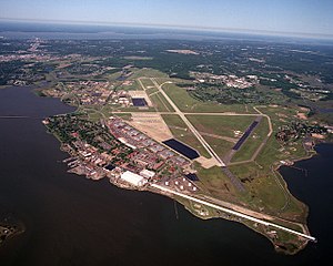
Langley Air Force Base (IATA: LFI, ICAO: KLFI, FAA LID: LFI) is a United States Air Force base located adjacent to Hampton and Newport News, Virginia. It was one of thirty-two Air Service training camps established after the entry of the United States into World War I in April 1917.
On 1 October 2010, Langley Air Force Base was joined with Fort Eustis to become Joint Base Langley–Eustis. The base was established in accordance with congressional legislation implementing the recommendations of the 2005 Base Realignment and Closure Commission. The legislation ordered the consolidation of the two facilities which were nearby, but separate military installations, into a single joint base, one of 12 formed in the United States as a result of the law.
The Air Force mission at Langley is to sustain the ability for fast global deployment and air superiority for the United States or allied armed forces. The base is one of the oldest facilities of the Air Force, having been established on 30 December 1916, prior to America's entry to World War I by the Army Air Service, named for aviation pioneer Samuel Pierpont Langley. It was used during World War I as a flying field, balloon station, observers’ school, photography school, experimental engineering department, and for aerial coast defense. It is situated on 3,152 acres of land between the cities of Hampton (south), NASA LaRC (west), and the northwest and southwest branches of the Back River.
...
Wikipedia

