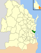
Landsborough Shire Council
|
City of Caloundra Queensland |
|||||||||||||||
|---|---|---|---|---|---|---|---|---|---|---|---|---|---|---|---|

Location within Queensland
|
|||||||||||||||
| Population | 90,341 (2006 census) | ||||||||||||||
| • Density | 82.647/km2 (214.054/sq mi) | ||||||||||||||
| Established | 1912 | ||||||||||||||
| Area | 1,093.1 km2 (422.0 sq mi) | ||||||||||||||
| Council seat | Caloundra | ||||||||||||||
| Region | Sunshine Coast | ||||||||||||||
 |
|||||||||||||||
| Website | City of Caloundra | ||||||||||||||
|
|||||||||||||||
The City of Caloundra was a local government area about 90 kilometres (56 mi) north of Brisbane in the Sunshine Coast region of South East Queensland, Australia. The shire covered an area of 1,093.1 square kilometres (422.0 sq mi), and existed as a local government entity from 1912 until 2008, when it amalgamated with councils further north to form the Sunshine Coast Region.
The City covered the urban localities of Caloundra and Kawana Waters and surrounding suburbs, the northern half of Bribie Island and the western hinterland towns of Landsborough, Maleny and Witta.
In 1868, the Queensland Government opened up large areas of land for settlement in the Caloundra area which became home to pioneers and timber cutters seeking red cedar wood.
The area was originally incorporated as part of the Caboolture Division on 11 November 1879 under the Divisional Boards Act 1879. With the passage of the Local Authorities Act 1902, Caboolture Division became Shire of Caboolture on 31 March 1903.
On 22 February 1912, part of the Shire of Caboolture was split away and was proclaimed as the Shire of Landsborough. John Tytherleigh, a local businessman with stores in the area, was elected its first chairman and they quickly set to work building the (now heritage-listed) Landsborough Shire Council Chambers in Landsborough. It was reconstructed from local timbers under the guidance of architect Walter Voller in 1924, and the building is today used as a museum housing artefacts including former Premier Frank Nicklin's personal collection.
...
Wikipedia
