Landsat 8

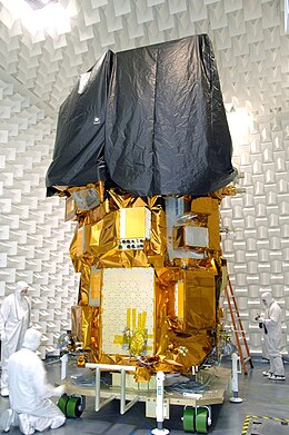
Landsat 8 during ground testing
|
|
| Mission type | Earth imaging |
|---|---|
| Operator | NASA / USGS |
| COSPAR ID | 2013-008A |
| SATCAT no. | 39084 |
| Website | landsat.usgs.gov/landsat8 |
| Mission duration | 5–10 years (planned) Elapsed: 4 years, 2 months, 23 days |
| Spacecraft properties | |
| Bus | LEOStar-3 |
| Manufacturer |
Orbital Sciences (prime) Ball Aerospace (OLI) NASA GSFC (TIRS) |
| Launch mass | 2,623 kilograms (5,783 lb) |
| Dry mass | 1,512 kilograms (3,333 lb) |
| Start of mission | |
| Launch date | 11 February 2013, 18:02 UTC |
| Rocket | Atlas V 401 AV-035 |
| Launch site | Vandenberg SLC-3E |
| Contractor | United Launch Alliance |
| Entered service | 30 May 2013 |
| Orbital parameters | |
| Reference system | Geocentric |
| Regime | Sun-synchronous |
| Semi-major axis | 7,080.48 kilometers (4,399.61 mi) |
| Eccentricity | 0.0001310 |
| Perigee | 701.0 kilometers (435.6 mi) |
| Apogee | 703.0 kilometers (436.8 mi) |
| Inclination | 98.2248° |
| Period | 98.8 minutes |
| RAAN | 219.1493 degrees |
| Argument of perigee | 91.0178 degrees |
| Mean anomaly | 269.1170 degrees |
| Mean motion | 14.57127432 |
| Epoch | 28 May 2016, 04:43:16 UTC |
 |
|
Landsat 8 is an American Earth observation satellite launched on February 11, 2013. It is the eighth satellite in the Landsat program; the seventh to reach orbit successfully. Originally called the Landsat Data Continuity Mission (LDCM), it is a collaboration between NASA and the United States Geological Survey (USGS). NASA Goddard Space Flight Center in Greenbelt, Maryland, provided development, mission systems engineering, and acquisition of the launch vehicle while the USGS provided for development of the ground systems and will conduct on-going mission operations.
The satellite was built by Orbital Sciences Corporation, who served as prime contractor for the mission. The spacecraft's instruments were constructed by Ball Aerospace and NASA's Goddard Space Flight Center, and its launch was contracted to United Launch Alliance. During the first 108 days in orbit, LDCM underwent checkout and verification by NASA and on 30 May 2013 operations were transferred from NASA to the USGS when LDCM was officially renamed to Landsat 8.
The original Landsat 8 plans called for NASA to purchase data meeting Landsat 8 specifications from a commercially owned and operated satellite system; however, after an evaluation of proposals received from industry, NASA cancelled the Request for Proposals in September 2003. In August 2004, a memorandum from the White House Office of Science and Technology Policy (OSTP) directed Federal agencies to place Landsat-type sensors on the National Polar-orbiting Operational Environmental Satellite System (NPOESS) platform. Following an evaluation of the technical complexity of this task, the strategy was adjusted and on December 23, 2005, the OSTP issued a memorandum directing NASA to implement the Landsat 8 in the form of a free-flyer spacecraft carrying an instrument referred to as the Operational Land Imager (OLI). In December 2009, a decision was made to add a thermal infrared sensor (TIRS) to the mission payload.
...
Wikipedia
