Lame Deer, Montana
|
Lame Deer, Montana Meaveʼhoʼeno |
|
|---|---|
| CDP | |

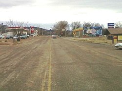
Looking south on Cheyenne Ave near the center of town.
|
|
 Location of Lame Deer, Montana |
|
| Coordinates: 45°37′19″N 0°39′29″W / 45.62194°N 0.65806°WCoordinates: 45°37′19″N 0°39′29″W / 45.62194°N 0.65806°W | |
| Country | United States |
| State | Montana |
| County | Rosebud |
| Area | |
| • Total | 55.6 sq mi (143.9 km2) |
| • Land | 55.6 sq mi (143.9 km2) |
| • Water | 0.0 sq mi (0.0 km2) |
| Elevation | 3,327 ft (1,014 m) |
| Population (2000) | |
| • Total | 2,018 |
| • Density | 36.3/sq mi (14.0/km2) |
| Time zone | Mountain (MST) (UTC-7) |
| • Summer (DST) | MDT (UTC-6) |
| ZIP code | 59043 |
| Area code(s) | 406 |
| FIPS code | 30-42250 |
| GNIS feature ID | 0773196 |
Lame Deer (Meaveʼhoʼeno in Cheyenne) is a census-designated place (CDP) in Rosebud County, Montana. The community is named after the Miniconjou Lakota chief Lame Deer who was killed by the U.S. Army in 1877 under a flag of truce south of the town. It is the tribal and government agency headquarters of the Northern Cheyenne Indian Reservation, home of the Chief Dull Knife College and hosts the annual Northern Cheyenne Powwow.
Lame Deer is located at (45.621819, -106.658079). According to the United States Census Bureau, the CDP has a total area of 55.6 square miles (144 km2), all land.
According to the Köppen Climate Classification system, Lame Deer has a semi-arid climate, abbreviated "BSk" on climate maps.
As of the census of 2010, there were 2,052 people, 521 households, and 401 families residing in the CDP. The population density was 36.3 people per square mile (14.0/km²). There are a total of 613 housing units, which makes at an average density of 10.3 per square mile (4.0/km²). The racial makeup was 4.3% White, 0.03% African American, 93.7% Native American, 0.01% Asian, 0.2% from other races, and 1.4% from two or more races. Hispanic or Latino of any race were 3.4% of the population. 67.9% spoke English, 28.9% Cheyenne and 2.7% Crow as their first language.
...
Wikipedia
