Lake Merritt
| Lake Merritt | |
|---|---|

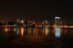
A view looking west toward the Lakeside Apartments District, the Tribune Tower and Downtown Oakland
|
|
| Location | East of downtown Oakland |
| Coordinates | 37°48′14″N 122°15′33″W / 37.8039°N 122.2591°WCoordinates: 37°48′14″N 122°15′33″W / 37.8039°N 122.2591°W |
| Lake type | recreation, lagoon, wildlife refuge |
| Basin countries | United States |
| Surface area | 140 acres (0.57 km2) |
| Max. depth | 10 feet (3.0 m) |
| Shore length1 | 3.4 miles (5.5 km) |
| Surface elevation | 43 feet (13 m) |
| Frozen | No |
|
Lake Merritt Wild Duck Refuge
|
|

Looking Southwest across Lake Merritt. In the distance are the Rene C. Davidson Alameda County Court House and Henry J. Kaiser Convention Center. At the right is the Bellevue-Staten Building.
|
|
| Built | 1870 |
| NRHP Reference # | 66000205 |
| Significant dates | |
| Added to NRHP | October 15, 1966 |
| Designated NHL | May 23, 1963 |
| 1 Shore length is not a well-defined measure. | |
Lake Merritt is a large tidal lagoon in the center of Oakland, California, just east of Downtown. It is surrounded by parkland and city neighborhoods. It is historically significant as the United States' first official wildlife refuge, designated in 1870, and has been listed on the National Register of Historic Places since 1966. The lake features grassy shores; several artificial islands intended as bird refuges; an interpretive center called the Rotary Nature Center; a boating center where sailboats, canoes and rowboats can be rented and classes are held; and a fairy tale themed amusement park called Children's Fairyland. A popular walking and jogging path runs along its perimeter. The circumference of the lake is 3.4 miles (5.5 km) and its area is 155 acres (63 ha).
The lake was originally an arm of the San Francisco Bay formed where several creeks empty into the bay. It was surrounded by 1,000 acres (4 km2) of wetlands when the Ohlone people fished, hunted and gathered food along its shores. By 1810, the remaining Native Americans were removed to Mission San José and the estuary and 44,800 acres (181 km2) of surrounding land was deeded to Sergeant Luis Maria Peralta to become Rancho San Antonio. After gold was discovered in 1848 in present-day Coloma 125 miles (201 km) to the northeast, Anglo squatters led by lawyer Horace Carpentier took control of the East Bay area which was to become downtown Oakland, including the estuary known as "San Antonio Slough." In 1856, Peralta fought and won a United States Supreme Court case against the squatters but further court cases between his sons and daughters would greatly diminish their holdings. The Peralta brothers had to sell much of the land to Carpentier to pay legal fees and new property taxes. Oakland was incorporated in 1852 with Carpentier as its first mayor and the estuary became the city's sewer.
...
Wikipedia
