Lake Mackay
| Lake Mackay Wilkinkarra |
|
|---|---|

From space (November 1989)
|
|
|
Location on the Northern Territory and Western Australian border
|
|
| Location | Western Australia and Northern Territory |
| Coordinates | 22°30′S 128°35′E / 22.500°S 128.583°ECoordinates: 22°30′S 128°35′E / 22.500°S 128.583°E |
| Type | Salt lake |
| Basin countries | Australia |
| Max. length | 100 km (62 mi) |
| Max. width | 100 km (62 mi) |
| Surface area | 3,494 km2 (1,349 sq mi) |
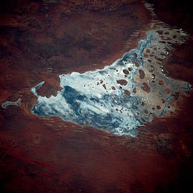
Lake Mackay (Pitjantjatjara: Wilkinkarra) is the largest of hundreds of ephemeral salt lakes scattered throughout Western Australia and the Northern Territory. The satellite image documents the appearance of the dry parts of Western Australia’s Great Sandy Desert, Gibson Desert, and Tanami Desert.
The lake is the largest in Western Australia and has a surface area of 3,494 square kilometres (1,349 sq mi). Its elevation ranges between 355 m (1,165 ft) and 370 m (1,210 ft) above mean sea-level.
Named after its European discoverer, Donald George Mackay, Lake Mackay is the fourth largest lake in Australia. Explorer David Carnegie in 1897 predicted its existence when he passed by the lake to the west as quoted in his book Spinifex and Sand. "May 9th we left the well on a Southerly course, and were soon amongst the ridges, which continued for the next two days. The night of the 11th, having skirted a line of rough cliffs, we camped about three miles North of a very prominent single hill, which I named Mount Webb, after W. F. Webb, Esq., of Newstead Abbey, Nottinghamshire. As the sun rose that morning the mirage of a lake of apparently great size was visible for 90° of the horizon — that is, from East round to South. Neither from the cliffs that we skirted, nor from Mount Webb, was any lake visible, but it is more than probable that a large salt lake exists in this locality, possibly connecting, in a broken line, Lake White and Lake Macdonald."
It measures approximately 100 kilometres (60 mi) east-west and north-south. The darker areas of the lakebed are indicative of some form of desert vegetation or algae, some moisture within the soils of the dry lake, and the lowest elevations where pooling of water occurs. In this arid environment, salts and other minerals are carried to the surface through capillary action caused by evaporation, thereby producing the white reflective surface. Visible are various brown hills scattered across the eastern half of the lake and east-west-oriented sand ridges south of the lake.
...
Wikipedia

