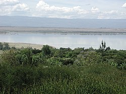
Lake Elementaita
| Lake Elmenteita | |
|---|---|
 |
|
| Coordinates | 0°27′S 36°15′E / 0.450°S 36.250°ECoordinates: 0°27′S 36°15′E / 0.450°S 36.250°E |
| Basin countries | Kenya |
| Surface area | 18 km2 (6.9 sq mi) |
| Surface elevation | 1,670 m (5,480 ft) ASL |
Lake Elmenteita, also spelled Elementaita, is a soda lake, in the Great Rift Valley, about 120 km northwest of Nairobi, Kenya.
Elmenteita is derived from the Masaai word muteita, meaning "dust place", a reference to the dryness and dustyness of the area, especially between January and March. The town of Gilgil is near the lake. In the south-to-north sequence of Rift Valley lakes, Elmenteita is between Lake Naivasha and Lake Nakuru. The major Nairobi-Nakuru highway (A104 Road) runs along the nearby escarpment affording motorists a spectacular vista towards the lake.Today the lake is a protected area due to its birdlife fame and also it has been named as one of the heritage sites together with the Lake Nakuru and Lake Bogoria by UNESCO.
At the southern end of the lake are the "Kekopey" hot springs, in which the Tilapia grahami breed. Very popular for bathing, the local Maasai claim that it can cure AIDS. The reed beds nearby are fishing grounds for night herons and pelicans.
The Lake Elmenteita area saw its first white settlement when Lord Delamere (1879-1931) established Soysambu, a 48,000-acre (190 km2) ranch, on the western side of the lake. Delamere gifted the land on the other side of the lake to his brother-in-law, the Honorable Galbraith Lowry Egerton Cole (1881-1929), part of whose "Kekopey Ranch", where he is buried, is preserved today as the Lake Elementaita Lodge.
Soysambu ranch is still occupied by Lord Delamere's descendants, including the controversial Thomas P. G. Cholmondeley who has been instrumental in setting up the Soysambu conservancy. The conservancy covers 2/3 of the shoreline and is home to over 12000 wild animals.
...
Wikipedia
