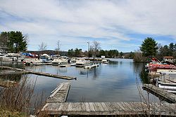
Lake Chaubunagungamaug
| Lake Chargoggagoggmanchauggagoggchaubunagungamaugg | |
|---|---|
 |
|
| Location | Webster, Massachusetts |
| Coordinates | 42°02′30″N 71°50′30″W / 42.04167°N 71.84167°WCoordinates: 42°02′30″N 71°50′30″W / 42.04167°N 71.84167°W |
| Basin countries | United States |
| Max. length | 3.25 mi (5.23 km) |
| Max. width | 1.125 mi (1.811 km) |
| Surface area | 1,442 acres (584 ha) |
| Shore length1 | 17 mi (27 km) |
| Surface elevation | 477 feet (145 m) |
| Islands | 8 |
| 1 Shore length is not a well-defined measure. | |
Lake Chaubunagungamaug, also known as Webster Lake, is a lake in the town of Webster, Massachusetts, United States. It is located near the Connecticut border and has a surface area of 1,442 acres (5.84 km2). Since 1921, the lake has also been known by a much longer name having 45 letters comprising fourteen syllables: Lake Chargoggagoggmanchauggagoggchaubunagungamaugg.
The lake's name comes from Nipmuc, an Algonquian language, and is often said to mean, "Fishing Place at the Boundaries -- Neutral Meeting Grounds". A more fitting translation is "lake divided by islands", according to anthropologist Ives Goddard.
Today, "Webster Lake" may be the name most used, but some (including many residents of Webster), take pride in reeling off the longer versions. This lake has several alternative names. Lake Chaubunagungamaug is the name of the lake as recognized by the U.S. Department of the Interior, and is the name appearing in the earliest local records.
Algonquian-speaking peoples had several different names for the lake as recorded on old maps and historical records. However, all of these were similar in part and had almost the same translation. Among other early names were "Chabanaguncamogue" and "Chaubanagogum". Early town records show the name as "Chabunagungamaug Pond", which was also the name of the local Nipmuc town (recorded in 1668 and 1674 with somewhat different spellings). This has been translated as "boundary fishing place", but something close to "fishing place at the boundary" or "that which is a divided island lake" may be more accurate.
A map of 1795, showing the town of Dudley, and a 1795 map of Massachusetts indicated the name as "Chargoggagoggmanchoggagogg". A survey of the lake done in 1830 lists the name as "Chaubunagungamaugg", the older name. The following year, both Dudley and Oxford, which then adjoined the lake, filed maps listing the name as "Chargoggagoggmanchoggagogg". Anthropologist Ives Goddard considers that 1831 name to be a cartographer's creation that corrupted the actual name while confusing this lake with nearby Manchaug Pond.
...
Wikipedia
