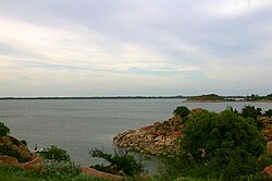
Lake Altus
| Lake Altus-Lugert | |
|---|---|

Lake Altus-Lugert, looking east
|
|
| Location | Greer / Kiowa counties, Oklahoma, United States |
| Coordinates | 34°55′30″N 99°18′08″W / 34.9251°N 99.3023°WCoordinates: 34°55′30″N 99°18′08″W / 34.9251°N 99.3023°W |
| Primary inflows | North Fork Red River |
| Primary outflows | North Fork Red River |
| Basin countries | United States |
| Surface area | 6,260 acres (25.3 km2) |
| Average depth | 21 ft (6.4 m) |
| Max. depth | 71 ft (22 m) |
| Water volume | 132,830 acre·ft (163,840,000 m3) |
| Shore length1 | 49 mi (79 km) |
| Surface elevation | 1,547 ft (472 m) |
| Settlements | Altus, Oklahoma |
| 1 Shore length is not a well-defined measure. | |
Lake Altus-Lugert, also known as Lake Altus and Lake Lugert is a reservoir located on the North Fork Red River, about 17 miles (27 km) north of Altus, Oklahoma on the former site of the town of Lugert, Oklahoma. The river is the boundary between Greer County and Kiowa County, Oklahoma. The lake is used for fishing, boating, swimming, and irrigation. However, toxic blooms of golden algae killed off nearly all adult fish early in 2013, making it unsuitable for fishing, temporarily. Heavy rains in 2015 ended an 8-year drought and refilled the lake with water. This is also the principal water supply for Altus.
Lake Lugert was created over the former town of Lugert (founded in 1902) which was destroyed by a tornado on April 27, 1912. One can see the old foundations of the houses which used to stand in the area. Layers of brick and weeds dominate the area making it hard to walk through when the lake is dry. The town was hit by a tornado several times leaving the town to only rebuild. Later after the last tornado hit the town, the towns people decided to leave, abandoning the entire town. Lake Altus has been expanded to include the town of Lugert, also creating Lake Lugert.
Lake Altus-Lugert is the primary storage facility for the W.C. Austin Project of the U.S. Bureau of Reclamation. This project provides irrigation water to some 48,000 acres (190 km²) of land located in southwestern Oklahoma.
Lake Altus had its beginnings in 1927 when the city of Altus, Oklahoma built Altus Dam as a source of municipal water for the city. Interest in providing irrigation water to farmers in the region prompted the U.S. Government to authorize construction of a larger reservoir in the Rivers and Harbors Act of 1938. The dam was to be raised 50 feet (15 m) to impound more water. Construction started in 1941, and was interrupted by World War II. Construction resumed in 1944. The dam, as it stands today, was completed in 1947.
There is also an extensive system of canals leaving Lake Altus in order to deliver the irrigation water to farmland. Most of these canals and distribution laterals were completed by 1953.
...
Wikipedia
