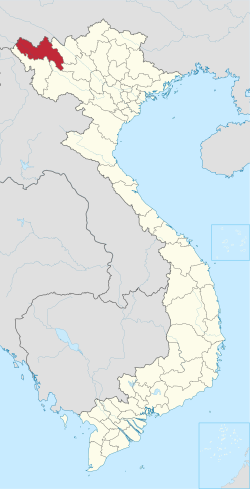
Lai Châu Province
|
Lai Châu Province Tỉnh Lai Châu |
|
|---|---|
| Province | |
 Location of Lai Châu within Vietnam |
|
| Coordinates: 22°0′N 103°0′E / 22.000°N 103.000°ECoordinates: 22°0′N 103°0′E / 22.000°N 103.000°E | |
| Country |
|
| Region | Northwest |
| Capital | Lai Châu |
| Government | |
| • People's Council Chair | Lỳ Khai Phà |
| • People's Committee Chair | Lò Văn Giàng |
| Area | |
| • Total | 9,068.8 km2 (3,501.5 sq mi) |
| Population (2014) | |
| • Total | 415,300 |
| • Density | 46/km2 (120/sq mi) |
| Demographics | |
| • Ethnicities | Tai, H'Mông, Vietnamese, Giáy, Dao |
| Time zone | ICT (UTC+7) |
| Area codes | 213 |
| ISO 3166 code | VN-01 |
| Website | www |
Lai Châu (![]() listen) is a province in the Northwest region of Vietnam. Lai Châu Province is the most sparsely populated in Vietnam. It shares a border with China. It once was a semi-independent White Tai confederation known as Sipsongchuthai, but was absorbed by France into French Indochina in the 1880s and subsequently became part of Vietnam following Vietnamese independence in 1954. It became part of the Northwest Autonomous Area of the Democratic Republic of Vietnam from 1955 to 1975, when Lai Châu Province was formed. Điện Biên Province was carved out of Lai Châu in 2004.
listen) is a province in the Northwest region of Vietnam. Lai Châu Province is the most sparsely populated in Vietnam. It shares a border with China. It once was a semi-independent White Tai confederation known as Sipsongchuthai, but was absorbed by France into French Indochina in the 1880s and subsequently became part of Vietnam following Vietnamese independence in 1954. It became part of the Northwest Autonomous Area of the Democratic Republic of Vietnam from 1955 to 1975, when Lai Châu Province was formed. Điện Biên Province was carved out of Lai Châu in 2004.
Sipsongchuthai is a Tai Lü compound consisting of sibsong "twelve" and chu "master". It is cognate to Template:Lang-t, and may rendered in English as "Twelve Tai Kingdoms" or "Chiefdoms", according to relative standing in the Southeast Asian mandala political model, in allusion to either a Chief of the Name or a tribal chief. Sibsong derives from Chinese (ten) and (pair). "Chu", (rendered in Tai as จุ or in longer form ,) derives from Middle Chinese 主 (ćǘ) "master."
Lai Châu is subdivided into 8 district-level sub-divisions:
They are further subdivided into 7 commune-level towns (or townlets), 96 communes, and 5 wards.
...
Wikipedia
