Ladbroke Grove
| Ladbroke Grove | |
|---|---|
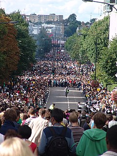
 Crowds on Ladbroke Grove during the Notting Hill Carnival |
|
| Ladbroke Grove shown within Greater London | |
| OS grid reference | TQ 243812 |
| Ceremonial county | Greater London |
| Region | |
| Country | England |
| Sovereign state | United Kingdom |
| Post town | LONDON |
| Postcode district | W11 & W10 |
| Dialling code | 020 |
| Police | Metropolitan |
| Fire | London |
| Ambulance | London |
| EU Parliament | London |
| UK Parliament | |
Ladbroke Grove (/ˈlædbrʊk/) is a North-west London road in the Royal Borough of Kensington and Chelsea, running north/south between Holland Park Avenue and Harrow Road. It is also the name given to the immediate surrounding area of Notting Hill and North Kensington, straddling the W10 and W11 postal districts. Ladbroke Grove tube station is located on the road, at the point where it is crossed by the Westway. The adjacent bridge and nearby section of the Westway (London) was regenerated in 2007 in a partnership including Urban Eye, Transport for London and London Underground. It is also the nearest tube station to Portobello Road Market. It is the main road on the route of the annual Notting Hill Carnival in August. The northern tip of the road is located in Kensal Green, with the southern end in Notting Hill.
The street is named after James Weller Ladbroke, who developed the Ladbroke Estate in the mid-19th century, until then a largely rural area on the western edges of London. The Anglican church of St Michael and All Angels in the road was designed by James Edmeston and built in the Romanesque style in 1871. Hablot Knight Browne, the cartoonist who illustrated Charles Dickens' novels as "Phiz", lived at No. 99 in 1872-80.
...
Wikipedia

